Troy geodata
Troy (Michigan) is a populated place; located in United States in America/Detroit (GMT-4) time zone. With population of 83,280 people, there are 469 cities with bigger population in this country. Compared to other cities in United States, 80.6% of cities are located further ↓South; 61.6% of cities are located further ←West and 58.2% of cities have lower elevation than Troy. Note1


Troy GPS coordinates[2]
42° 36' 20.124" North, 83° 8' 59.748" West
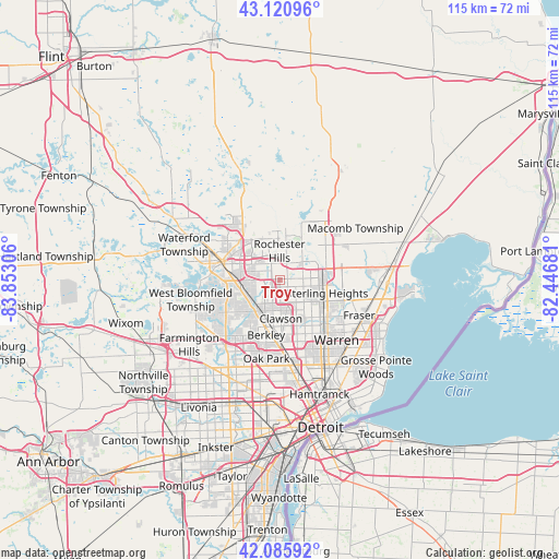
| Map corner | latitude | longitude |
|---|---|---|
| Upper-left | 43.12096°, | -83.85306° |
| Center: | 42.60559°, | -83.14993° |
| Lower-right: | 42.08592°, | -82.44681° |
| Map W x H: | 115.1×115.1 km | = 71.5×71.5mi |
| max Lat: | 71.29058° ⇑19.4% North |
| Troy: | 42.60559° |
| min Lat: | ⇓80.6% South 19.06759° |
| min Long | Troy | max Long |
| -171.73463° | -83.14993° | -66.98998° |
| W 61.6%⇐ | ⇒38.4% E |
Elevation
Elevation of Troy is 231 m = 758 ft, and this is 63.8 m = 209 ft below average elevation for this country.
| Max E: |
3189 m = 10463 ft | 41.8% |
| Avg. | 294.8 m = 967 ft | |
| Troy | 231 m = 758 ft | |
Min E: |
-60 m = -197 ft | 58.2% |
See also: Troy elevation on elevation.city.
Geographical zone
Troy is located in North temperate zone (between Tropic of Cancer and the Arctic Circle). Distance of this Northern Tropic circle is 2131.4 km =1324.4 mi to South.| Distance of | km | miles | from Troy |
|---|---|---|---|
| North Pole | 5269.8 | 3274.5 | to North |
| Arctic Circle | 2663.9 | 1655.3 | to North |
| Tropic Cancer | 2131.4 | 1324.4 | to South |
| Equator | 4737.3 | 2943.6 | to South |


Nearby cities:
15 places around Troy: (largest is in red/bold)
• Auburn Hills
11.4 km =7.1 mi,  322°
322°
• Berkley
11.7 km =7.3 mi,  193°
193°
• Beverly Hills
10.9 km =6.8 mi,  213°
213°
• Birmingham
8.3 km =5.2 mi,  217°
217°
• Bloomfield Hills
8.2 km =5.1 mi,  252°
252°
• Clawson
8 km =5 mi,  177°
177°
• Lathrup Village
13.5 km =8.4 mi, 206°
• Madison Heights
13.8 km =8.6 mi,  164°
164°
• Pontiac
12.1 km =7.5 mi,  287°
287°
• Rochester
8.4 km =5.2 mi,  8°
8°
• Rochester Hills
5.9 km =3.7 mi,  0°
0°
• Royal Oak
12.9 km =8 mi, 178°
• Shelby
12 km =7.5 mi,  52°
52°
• Sterling Heights
10.2 km =6.3 mi,  106°
106°
• Utica
9.8 km =6.1 mi,  76°
76°
Sources, notices
• [Note1] Compared only with cities in United States existing in our database
• [Src1] Map data: © OpenStreetMap contributors (CC-BY-SA)
• [Src2] Other city data from geonames.org with taken over terms of usage.
• [Src3] Geographical zone / Annual Mean Temperature by Robert A. Rohde @ Wikipedia
