Rochester geodata
Rochester (Michigan) is a populated place; located in United States in America/Detroit (GMT-4) time zone. With population of 12,993 people, there are 3676 cities with bigger population in this country. Compared to other cities in United States, 81.1% of cities are located further ↓South; 61.7% of cities are located further ←West and 58.4% of cities have lower elevation than Rochester. Note1


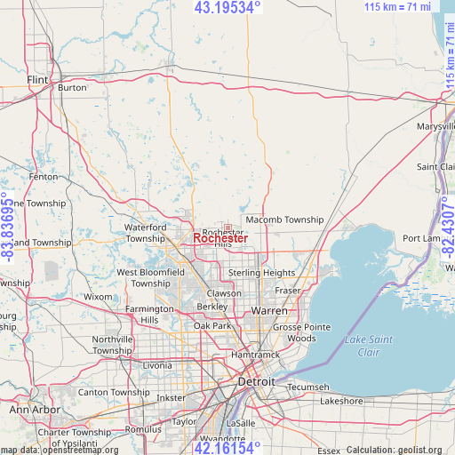
Rochester GPS coordinates[2]
42° 40' 50.124" North, 83° 8' 1.752" West
| Map corner | latitude | longitude |
|---|---|---|
| Upper-left | 43.19534°, | -83.83695° |
| Center: | 42.68059°, | -83.13382° |
| Lower-right: | 42.16154°, | -82.4307° |
| Map W x H: | 114.9×114.9 km | = 71.4×71.4mi |
| max Lat: | 71.29058° ⇑18.9% North |
| Rochester: | 42.68059° |
| min Lat: | ⇓81.1% South 19.06759° |
| min Long | Rochester | max Long |
| -171.73463° | -83.13382° | -66.98998° |
| W 61.7%⇐ | ⇒38.3% E |
Elevation
Elevation of Rochester is 232 m = 761 ft, and this is 62.8 m = 206 ft below average elevation for this country.
| Max E: |
3189 m = 10463 ft | 41.6% |
| Avg. | 294.8 m = 967 ft | |
| Rochester | 232 m = 761 ft | |
Min E: |
-60 m = -197 ft | 58.4% |
See also: United States elevation on elevation.city.
Geographical zone
Rochester is located in North temperate zone (between Tropic of Cancer and the Arctic Circle). Distance of this Northern Tropic circle is 2139.7 km =1329.5 mi to South.| Distance of | km | miles | from Rochester |
|---|---|---|---|
| North Pole | 5261.4 | 3269.3 | to North |
| Arctic Circle | 2655.5 | 1650.1 | to North |
| Tropic Cancer | 2139.7 | 1329.5 | to South |
| Equator | 4745.6 | 2948.8 | to South |


Nearby cities:
15 places around Rochester: (largest is in red/bold)
• Auburn Hills
8.2 km =5.1 mi,  275°
275°
• Beverly Hills
18.9 km =11.7 mi,  202°
202°
• Birmingham
16.2 km =10.1 mi, 203°
• Bloomfield Hills
14.1 km =8.8 mi,  220°
220°
• Clawson
16.4 km =10.2 mi,  183°
183°
• Keego Harbor
19 km =11.8 mi,  244°
244°
• Lake Orion
14.4 km =8.9 mi,  323°
323°
• Pontiac
13.7 km =8.5 mi,  250°
250°
• Rochester Hills
2.8 km =1.7 mi,  208°
208°
• Romeo
16.8 km =10.4 mi,  35°
35°
• Shelby
8.3 km =5.2 mi,  97°
97°
• Sterling Heights
14 km =8.7 mi,  142°
142°
• Sylvan Lake
17.7 km =11 mi, 244°
• Troy
8.4 km =5.2 mi,  188°
188°
• Utica
10.2 km =6.3 mi,  126°
126°
Sources, notices
• [Note1] Compared only with cities in United States existing in our database
• [Src1] Map data: © OpenStreetMap contributors (CC-BY-SA)
• [Src2] Other city data from geonames.org with taken over terms of usage.
• [Src3] Geographical zone / Annual Mean Temperature by Robert A. Rohde @ Wikipedia
