Mount Clemens geodata
Mount Clemens (Michigan) is a seat of a second-order administrative division; located in United States in America/Detroit (GMT-4) time zone. With population of 16,400 people, there are 2994 cities with bigger population in this country. Compared to other cities in United States, 80.5% of cities are located further ↓South; 62.4% of cities are located further ←West and 52.8% of cities have higher elevation than Mount Clemens. Note1


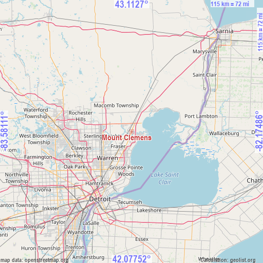
Mount Clemens GPS coordinates[2]
42° 35' 50.136" North, 82° 52' 40.728" West
| Map corner | latitude | longitude |
|---|---|---|
| Upper-left | 43.1127°, | -83.58111° |
| Center: | 42.59726°, | -82.87798° |
| Lower-right: | 42.07752°, | -82.17486° |
| Map W x H: | 115.1×115.1 km | = 71.5×71.5mi |
| max Lat: | 71.29058° ⇑19.5% North |
| Mount Clemens: | 42.59726° |
| min Lat: | ⇓80.5% South 19.06759° |
| min Long | Mount Clemens | max Long |
| -171.73463° | -82.87798° | -66.98998° |
| W 62.4%⇐ | ⇒37.6% E |
Elevation
Elevation of Mount Clemens is 188 m = 617 ft, and this is 106.8 m = 350 ft below average elevation for this country.
| Max E: |
3189 m = 10463 ft | 52.8% |
| Avg. | 294.8 m = 967 ft | |
| Mount Clemens | 188 m = 617 ft | |
Min E: |
-60 m = -197 ft | 47.2% |
See also: United States elevation on elevation.city.
Geographical zone
Mount Clemens is located in North temperate zone (between Tropic of Cancer and the Arctic Circle). Distance of this Northern Tropic circle is 2130.5 km =1323.8 mi to South.| Distance of | km | miles | from Mount Clemens |
|---|---|---|---|
| North Pole | 5270.7 | 3275.1 | to North |
| Arctic Circle | 2664.8 | 1655.8 | to North |
| Tropic Cancer | 2130.5 | 1323.8 | to South |
| Equator | 4736.4 | 2943.1 | to South |


Nearby cities:
15 places around Mount Clemens: (largest is in red/bold)
• Center Line
17.5 km =10.9 mi,  224°
224°
• Clinton Township
3.6 km =2.2 mi,  251°
251°
• Eastpointe
15.7 km =9.8 mi,  203°
203°
• Fraser
8.7 km =5.4 mi, 222°
• Grosse Pointe Shores
17.9 km =11.1 mi,  179°
179°
• Grosse Pointe Woods
17.2 km =10.7 mi,  187°
187°
• Harper Woods
18.6 km =11.6 mi, 191°
• New Baltimore
14.8 km =9.2 mi,  51°
51°
• New Haven
16 km =9.9 mi,  23°
23°
• Roseville
12.1 km =7.5 mi, 203°
• Saint Clair Shores
11.2 km =7 mi, 184°
• Shelby
15.1 km =9.4 mi,  302°
302°
• Sterling Heights
12.6 km =7.8 mi,  261°
261°
• Utica
13.1 km =8.1 mi,  284°
284°
• Warren
16.2 km =10.1 mi, 222°
Sources, notices
• [Note1] Compared only with cities in United States existing in our database
• [Src1] Map data: © OpenStreetMap contributors (CC-BY-SA)
• [Src2] Other city data from geonames.org with taken over terms of usage.
• [Src3] Geographical zone / Annual Mean Temperature by Robert A. Rohde @ Wikipedia
