Saranac geodata
Saranac (Michigan) is a populated place; located in United States in America/Detroit (GMT-4) time zone. With population of 1,333 people, there are 14419 cities with bigger population in this country. Compared to other cities in United States, 82.7% of cities are located further ↓South; 55.3% of cities are located further ←West and 50.8% of cities have higher elevation than Saranac. Note1


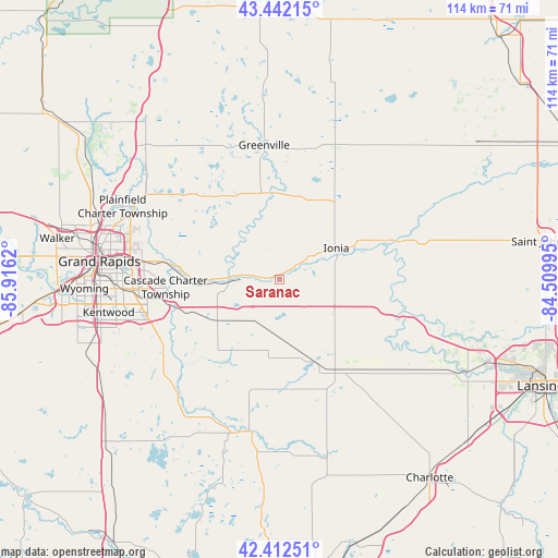
Saranac GPS coordinates[2]
42° 55' 46.128" North, 85° 12' 47.052" West
| Map corner | latitude | longitude |
|---|---|---|
| Upper-left | 43.44215°, | -85.9162° |
| Center: | 42.92948°, | -85.21307° |
| Lower-right: | 42.41251°, | -84.50995° |
| Map W x H: | 114.5×114.5 km | = 71.1×71.1mi |
| max Lat: | 71.29058° ⇑17.3% North |
| Saranac: | 42.92948° |
| min Lat: | ⇓82.7% South 19.06759° |
| min Long | Saranac | max Long |
| -171.73463° | -85.21307° | -66.98998° |
| W 55.3%⇐ | ⇒44.7% E |
Elevation
Elevation of Saranac is 195 m = 640 ft, and this is 99.8 m = 327 ft below average elevation for this country.
| Max E: |
3189 m = 10463 ft | 50.8% |
| Avg. | 294.8 m = 967 ft | |
| Saranac | 195 m = 640 ft | |
Min E: |
-60 m = -197 ft | 49.2% |
See also: United States elevation on elevation.city.
Geographical zone
Saranac is located in North temperate zone (between Tropic of Cancer and the Arctic Circle). Distance of this Northern Tropic circle is 2167.4 km =1346.8 mi to South.| Distance of | km | miles | from Saranac |
|---|---|---|---|
| North Pole | 5233.8 | 3252.1 | to North |
| Arctic Circle | 2627.9 | 1632.9 | to North |
| Tropic Cancer | 2167.4 | 1346.8 | to South |
| Equator | 4773.3 | 2966 | to South |


Nearby cities:
15 places around Saranac: (largest is in red/bold)
• Belding
18.8 km =11.7 mi,  356°
356°
• Caledonia
29.3 km =18.2 mi,  237°
237°
• East Grand Rapids
32.3 km =20.1 mi,  272°
272°
• Forest Hills
22.8 km =14.2 mi,  278°
278°
• Greenville
27.8 km =17.3 mi,  353°
353°
• Hastings
32.2 km =20 mi,  191°
191°
• Ionia
13.2 km =8.2 mi,  60°
60°
• Lake Odessa
17.2 km =10.7 mi,  159°
159°
• Lowell
10.5 km =6.5 mi, 272°
• Lyons
22.4 km =13.9 mi,  74°
74°
• Middleville
31.5 km =19.6 mi,  220°
220°
• Muir
23.2 km =14.4 mi, 71°
• Mulliken
31.8 km =19.8 mi,  125°
125°
• Portland
26.1 km =16.2 mi,  104°
104°
• Sunfield
25.9 km =16.1 mi,  135°
135°
Sources, notices
• [Note1] Compared only with cities in United States existing in our database
• [Src1] Map data: © OpenStreetMap contributors (CC-BY-SA)
• [Src2] Other city data from geonames.org with taken over terms of usage.
• [Src3] Geographical zone / Annual Mean Temperature by Robert A. Rohde @ Wikipedia
