Muir geodata
Muir (Michigan) is a populated place; located in United States in America/Detroit (GMT-4) time zone. With population of 605 people, there are 19636 cities with bigger population in this country. Compared to other cities in United States, 83.2% of cities are located further ↓South; 56% of cities are located further ←West and 50% of cities have lower elevation than Muir. Note1


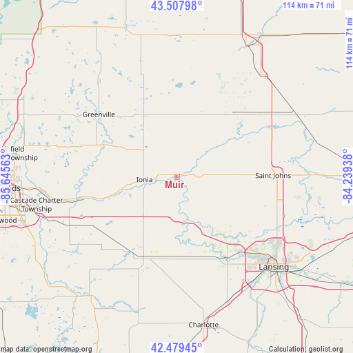
Muir GPS coordinates[2]
42° 59' 45.132" North, 84° 56' 33" West
| Map corner | latitude | longitude |
|---|---|---|
| Upper-left | 43.50798°, | -85.64563° |
| Center: | 42.99587°, | -84.9425° |
| Lower-right: | 42.47945°, | -84.23938° |
| Map W x H: | 114.4×114.4 km | = 71.1×71.1mi |
| max Lat: | 71.29058° ⇑16.8% North |
| Muir: | 42.99587° |
| min Lat: | ⇓83.2% South 19.06759° |
| min Long | Muir | max Long |
| -171.73463° | -84.9425° | -66.98998° |
| W 56%⇐ | ⇒44% E |
Elevation
Elevation of Muir is 198 m = 650 ft, and this is 96.8 m = 318 ft below average elevation for this country.
| Max E: |
3189 m = 10463 ft | 50% |
| Avg. | 294.8 m = 967 ft | |
| Muir | 198 m = 650 ft | |
Min E: |
-60 m = -197 ft | 50% |
See also: United States elevation on elevation.city.
Geographical zone
Muir is located in North temperate zone (between Tropic of Cancer and the Arctic Circle). Distance of this Northern Tropic circle is 2174.8 km =1351.4 mi to South.| Distance of | km | miles | from Muir |
|---|---|---|---|
| North Pole | 5226.4 | 3247.5 | to North |
| Arctic Circle | 2620.5 | 1628.3 | to North |
| Tropic Cancer | 2174.8 | 1351.4 | to South |
| Equator | 4780.7 | 2970.6 | to South |


Nearby cities:
15 places around Muir: (largest is in red/bold)
• Belding
25.9 km =16.1 mi,  295°
295°
• Carson City
21.6 km =13.4 mi,  21°
21°
• Fowler
16.5 km =10.3 mi,  87°
87°
• Ionia
10.5 km =6.5 mi,  264°
264°
• Lake Odessa
28.4 km =17.6 mi,  214°
214°
• Lyons
1.6 km =1 mi,  193°
193°
• Maple Rapids
23.7 km =14.7 mi,  59°
59°
• Mulliken
26.2 km =16.3 mi,  171°
171°
• Portland
14.4 km =8.9 mi, 167°
• Saint Johns
31.2 km =19.4 mi, 88°
• Saranac
23.2 km =14.4 mi,  251°
251°
• Sheridan
26.3 km =16.3 mi,  336°
336°
• Sunfield
26.3 km =16.3 mi, 188°
• Wacousta
27.1 km =16.8 mi,  133°
133°
• Westphalia
13.8 km =8.6 mi,  122°
122°
Sources, notices
• [Note1] Compared only with cities in United States existing in our database
• [Src1] Map data: © OpenStreetMap contributors (CC-BY-SA)
• [Src2] Other city data from geonames.org with taken over terms of usage.
• [Src3] Geographical zone / Annual Mean Temperature by Robert A. Rohde @ Wikipedia
