Climax geodata
Climax (Michigan) is a populated place; located in United States in America/Detroit (GMT-4) time zone. With population of 781 people, there are 17971 cities with bigger population in this country. Compared to other cities in United States, 77.7% of cities are located further ↓South; 55% of cities are located further ←West and 72.4% of cities have lower elevation than Climax. Note1


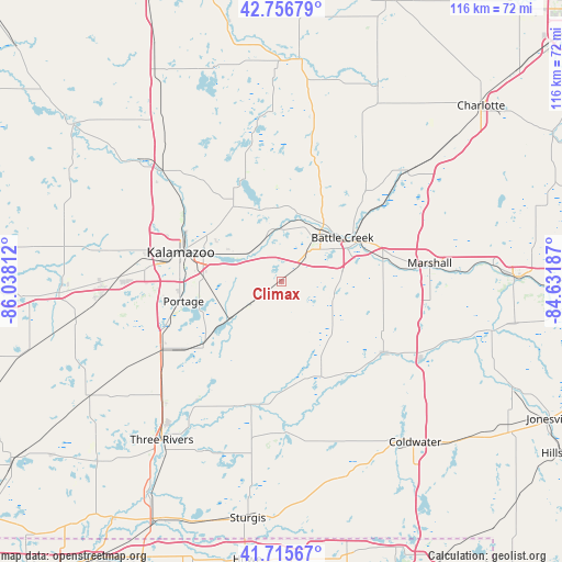
Climax GPS coordinates[2]
42° 14' 18.168" North, 85° 20' 5.964" West
| Map corner | latitude | longitude |
|---|---|---|
| Upper-left | 42.75679°, | -86.03812° |
| Center: | 42.23838°, | -85.33499° |
| Lower-right: | 41.71567°, | -84.63187° |
| Map W x H: | 115.8×115.8 km | = 72×72mi |
| max Lat: | 71.29058° ⇑22.3% North |
| Climax: | 42.23838° |
| min Lat: | ⇓77.7% South 19.06759° |
| min Long | Climax | max Long |
| -171.73463° | -85.33499° | -66.98998° |
| W 55%⇐ | ⇒45% E |
Elevation
Elevation of Climax is 298 m = 978 ft, and this is 3.2 m = 10 ft above average elevation for this country.
| Max E: |
3189 m = 10463 ft | 27.6% |
| Climax | 298 m 978 ft | |
| Avg. | 294.8 m = 967 ft | |
Min E: |
-60 m = -197 ft | 72.4% |
See also: United States elevation on elevation.city.
Geographical zone
Climax is located in North temperate zone (between Tropic of Cancer and the Arctic Circle). Distance of this Northern Tropic circle is 2090.5 km =1299 mi to South.| Distance of | km | miles | from Climax |
|---|---|---|---|
| North Pole | 5310.6 | 3299.9 | to North |
| Arctic Circle | 2704.7 | 1680.6 | to North |
| Tropic Cancer | 2090.5 | 1299 | to South |
| Equator | 4696.5 | 2918.3 | to South |


Nearby cities:
15 places around Climax: (largest is in red/bold)
• Athens
18.6 km =11.6 mi,  153°
153°
• Augusta
11 km =6.8 mi,  352°
352°
• Battle Creek
15.6 km =9.7 mi,  55°
55°
• Brownlee Park
18.2 km =11.3 mi, 60°
• Comstock Northwest
17.7 km =11 mi,  301°
301°
• Eastwood
19.1 km =11.9 mi,  292°
292°
• Galesburg
8.8 km =5.5 mi,  309°
309°
• Kalamazoo
21.6 km =13.4 mi, 285°
• Lakeview
12.2 km =7.6 mi, 56°
• Level Park-Oak Park
15.1 km =9.4 mi,  21°
21°
• Portage
20.6 km =12.8 mi,  258°
258°
• Richland
18.2 km =11.3 mi,  327°
327°
• South Gull Lake
17.3 km =10.7 mi,  342°
342°
• Springfield
12.6 km =7.8 mi,  38°
38°
• Vicksburg
20.9 km =13 mi,  231°
231°
Sources, notices
• [Note1] Compared only with cities in United States existing in our database
• [Src1] Map data: © OpenStreetMap contributors (CC-BY-SA)
• [Src2] Other city data from geonames.org with taken over terms of usage.
• [Src3] Geographical zone / Annual Mean Temperature by Robert A. Rohde @ Wikipedia
