Alexandria geodata
Alexandria (Minnesota) is a seat of a second-order administrative division; located in United States in America/Chicago (GMT-5) time zone. With population of 11,843 people, there are 3934 cities with bigger population in this country. Compared to other cities in United States, 94.9% of cities are located further ↓South; 72% of cities are located further →East and 85.2% of cities have lower elevation than Alexandria. Note1


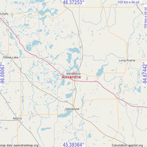
Alexandria GPS coordinates[2]
45° 53' 6.864" North, 95° 22' 39.144" West
| Map corner | latitude | longitude |
|---|---|---|
| Upper-left | 46.37253°, | -96.08067° |
| Center: | 45.88524°, | -95.37754° |
| Lower-right: | 45.39364°, | -94.67442° |
| Map W x H: | 108.8×108.8 km | = 67.6×67.6mi |
| max Lat: | 71.29058° ⇑5.1% North |
| Alexandria: | 45.88524° |
| min Lat: | ⇓94.9% South 19.06759° |
| min Long | Alexandria | max Long |
| -171.73463° | -95.37754° | -66.98998° |
| W 28%⇐ | ⇒72% E |
Elevation
Elevation of Alexandria is 429 m = 1407 ft, and this is 134.2 m = 440 ft above average elevation for this country.
| Max E: |
3189 m = 10463 ft | 14.8% |
| Alexandria | 429 m 1407 ft | |
| Avg. | 294.8 m = 967 ft | |
Min E: |
-60 m = -197 ft | 85.2% |
See also: United States elevation on elevation.city.
Geographical zone
Alexandria is located in North temperate zone (between Tropic of Cancer and the Arctic Circle). Distance of this North polar circle is 2299.2 km =1428.7 mi to North.| Distance of | km | miles | from Alexandria |
|---|---|---|---|
| North Pole | 4905.1 | 3047.9 | to North |
| Arctic Circle | 2299.2 | 1428.7 | to North |
| Tropic Cancer | 2496 | 1550.9 | to South |
| Equator | 5102 | 3170.2 | to South |


Nearby cities:
15 places around Alexandria: (largest is in red/bold)
• Brooten
47 km =29.2 mi,  155°
155°
• Browerville
45.4 km =28.2 mi,  60°
60°
• Clarissa
42.9 km =26.7 mi,  50°
50°
• Eagle Bend
40.6 km =25.2 mi,  40°
40°
• Elbow Lake
47.9 km =29.8 mi,  284°
284°
• Evansville
27.1 km =16.8 mi,  299°
299°
• Glenwood
26.1 km =16.2 mi,  182°
182°
• Henning
48.8 km =30.3 mi,  353°
353°
• Hoffman
32.7 km =20.3 mi,  259°
259°
• Long Prairie
40.8 km =25.4 mi,  75°
75°
• Melrose
50 km =31.1 mi,  117°
117°
• Osakis
17.6 km =10.9 mi,  96°
96°
• Parkers Prairie
30 km =18.6 mi,  7°
7°
• Sauk Centre
36.8 km =22.9 mi, 116°
• Starbuck
32.4 km =20.1 mi,  201°
201°
Sources, notices
• [Note1] Compared only with cities in United States existing in our database
• [Src1] Map data: © OpenStreetMap contributors (CC-BY-SA)
• [Src2] Other city data from geonames.org with taken over terms of usage.
• [Src3] Geographical zone / Annual Mean Temperature by Robert A. Rohde @ Wikipedia
