Elbow Lake geodata
Elbow Lake (Minnesota) is a seat of a second-order administrative division; located in United States in America/Chicago (GMT-5) time zone. With population of 1,144 people, there are 15417 cities with bigger population in this country. Compared to other cities in United States, 95% of cities are located further ↓South; 73.4% of cities are located further →East and 81.7% of cities have lower elevation than Elbow Lake. Note1


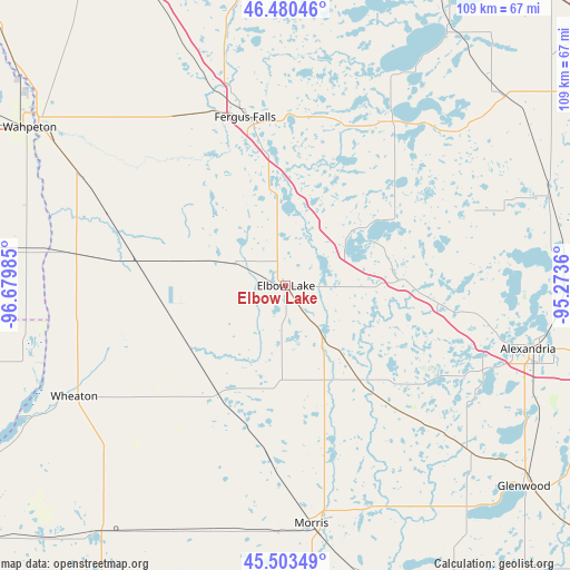
Elbow Lake GPS coordinates[2]
45° 59' 38.868" North, 95° 58' 36.192" West
| Map corner | latitude | longitude |
|---|---|---|
| Upper-left | 46.48046°, | -96.67985° |
| Center: | 45.99413°, | -95.97672° |
| Lower-right: | 45.50349°, | -95.2736° |
| Map W x H: | 108.6×108.6 km | = 67.5×67.5mi |
| max Lat: | 71.29058° ⇑5% North |
| Elbow Lake: | 45.99413° |
| min Lat: | ⇓95% South 19.06759° |
| min Long | Elbow Lake | max Long |
| -171.73463° | -95.97672° | -66.98998° |
| W 26.6%⇐ | ⇒73.4% E |
Elevation
Elevation of Elbow Lake is 373 m = 1224 ft, and this is 78.2 m = 257 ft above average elevation for this country.
| Max E: |
3189 m = 10463 ft | 18.3% |
| Elbow Lake | 373 m 1224 ft | |
| Avg. | 294.8 m = 967 ft | |
Min E: |
-60 m = -197 ft | 81.7% |
See also: United States elevation on elevation.city.
Geographical zone
Elbow Lake is located in North temperate zone (between Tropic of Cancer and the Arctic Circle). Distance of this North polar circle is 2287.1 km =1421.1 mi to North.| Distance of | km | miles | from Elbow Lake |
|---|---|---|---|
| North Pole | 4893 | 3040.4 | to North |
| Arctic Circle | 2287.1 | 1421.1 | to North |
| Tropic Cancer | 2508.1 | 1558.5 | to South |
| Equator | 5114.1 | 3177.8 | to South |


Nearby cities:
15 places around Elbow Lake: (largest is in red/bold)
• Alexandria
47.9 km =29.8 mi,  104°
104°
• Battle Lake
37.7 km =23.4 mi,  32°
32°
• Breckenridge
55.8 km =34.7 mi,  302°
302°
• Evansville
22.7 km =14.1 mi,  87°
87°
• Fergus Falls
33 km =20.5 mi,  346°
346°
• Graceville
59.1 km =36.7 mi,  216°
216°
• Hancock
57 km =35.4 mi,  165°
165°
• Henning
54.8 km =34.1 mi,  48°
48°
• Hoffman
23.2 km =14.4 mi,  142°
142°
• Morris
45.6 km =28.3 mi, 173°
• Ottertail
57.8 km =35.9 mi, 33°
• Parkers Prairie
53 km =32.9 mi,  70°
70°
• Starbuck
54.5 km =33.9 mi, 140°
• Wahpeton
57.1 km =35.5 mi, 301°
• Wheaton
45.6 km =28.3 mi,  242°
242°
Sources, notices
• [Note1] Compared only with cities in United States existing in our database
• [Src1] Map data: © OpenStreetMap contributors (CC-BY-SA)
• [Src2] Other city data from geonames.org with taken over terms of usage.
• [Src3] Geographical zone / Annual Mean Temperature by Robert A. Rohde @ Wikipedia
