Hoffman geodata
Hoffman (Minnesota) is a populated place; located in United States in America/Chicago (GMT-5) time zone. With population of 672 people, there are 18951 cities with bigger population in this country. Compared to other cities in United States, 94.8% of cities are located further ↓South; 73% of cities are located further →East and 82.2% of cities have lower elevation than Hoffman. Note1


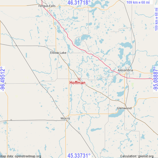
Hoffman GPS coordinates[2]
45° 49' 45.84" North, 95° 47' 31.164" West
| Map corner | latitude | longitude |
|---|---|---|
| Upper-left | 46.31718°, | -96.49512° |
| Center: | 45.8294°, | -95.79199° |
| Lower-right: | 45.33731°, | -95.08887° |
| Map W x H: | 109×109 km | = 67.7×67.7mi |
| max Lat: | 71.29058° ⇑5.2% North |
| Hoffman: | 45.8294° |
| min Lat: | ⇓94.8% South 19.06759° |
| min Long | Hoffman | max Long |
| -171.73463° | -95.79199° | -66.98998° |
| W 27%⇐ | ⇒73% E |
Elevation
Elevation of Hoffman is 379 m = 1243 ft, and this is 84.2 m = 276 ft above average elevation for this country.
| Max E: |
3189 m = 10463 ft | 17.8% |
| Hoffman | 379 m 1243 ft | |
| Avg. | 294.8 m = 967 ft | |
Min E: |
-60 m = -197 ft | 82.2% |
See also: United States elevation on elevation.city.
Geographical zone
Hoffman is located in North temperate zone (between Tropic of Cancer and the Arctic Circle). Distance of this North polar circle is 2305.4 km =1432.5 mi to North.| Distance of | km | miles | from Hoffman |
|---|---|---|---|
| North Pole | 4911.3 | 3051.7 | to North |
| Arctic Circle | 2305.4 | 1432.5 | to North |
| Tropic Cancer | 2489.8 | 1547.1 | to South |
| Equator | 5095.8 | 3166.4 | to South |


Nearby cities:
15 places around Hoffman: (largest is in red/bold)
• Alexandria
32.7 km =20.3 mi,  79°
79°
• Battle Lake
50.5 km =31.4 mi,  6°
6°
• Benson
59.1 km =36.7 mi,  165°
165°
• Elbow Lake
23.2 km =14.4 mi,  322°
322°
• Evansville
21.2 km =13.2 mi,  23°
23°
• Fergus Falls
55 km =34.2 mi,  336°
336°
• Glenwood
37 km =23 mi,  122°
122°
• Graceville
57.7 km =35.9 mi,  239°
239°
• Hancock
36.9 km =22.9 mi,  180°
180°
• Henning
60.9 km =37.8 mi,  26°
26°
• Morris
28.7 km =17.8 mi,  199°
199°
• Osakis
49.7 km =30.9 mi,  85°
85°
• Parkers Prairie
50.7 km =31.5 mi,  44°
44°
• Starbuck
31.3 km =19.4 mi,  139°
139°
• Wheaton
54.9 km =34.1 mi,  267°
267°
Sources, notices
• [Note1] Compared only with cities in United States existing in our database
• [Src1] Map data: © OpenStreetMap contributors (CC-BY-SA)
• [Src2] Other city data from geonames.org with taken over terms of usage.
• [Src3] Geographical zone / Annual Mean Temperature by Robert A. Rohde @ Wikipedia
