Baxter geodata
Baxter (Minnesota) is a populated place; located in United States in America/Chicago (GMT-5) time zone. With population of 7,934 people, there are 5313 cities with bigger population in this country. Compared to other cities in United States, 95.5% of cities are located further ↓South; 69.3% of cities are located further →East and 81.1% of cities have lower elevation than Baxter. Note1


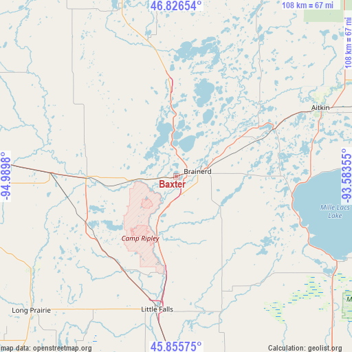
Baxter GPS coordinates[2]
46° 20' 35.88" North, 94° 17' 12.012" West
| Map corner | latitude | longitude |
|---|---|---|
| Upper-left | 46.82654°, | -94.9898° |
| Center: | 46.3433°, | -94.28667° |
| Lower-right: | 45.85575°, | -93.58355° |
| Map W x H: | 107.9×107.9 km | = 67×67mi |
| max Lat: | 71.29058° ⇑4.5% North |
| Baxter: | 46.3433° |
| min Lat: | ⇓95.5% South 19.06759° |
| min Long | Baxter | max Long |
| -171.73463° | -94.28667° | -66.98998° |
| W 30.7%⇐ | ⇒69.3% E |
Elevation
Elevation of Baxter is 366 m = 1201 ft, and this is 71.2 m = 234 ft above average elevation for this country.
| Max E: |
3189 m = 10463 ft | 18.9% |
| Baxter | 366 m 1201 ft | |
| Avg. | 294.8 m = 967 ft | |
Min E: |
-60 m = -197 ft | 81.1% |
See also: United States elevation on elevation.city.
Geographical zone
Baxter is located in North temperate zone (between Tropic of Cancer and the Arctic Circle). Distance of this North polar circle is 2248.3 km =1397 mi to North.| Distance of | km | miles | from Baxter |
|---|---|---|---|
| North Pole | 4854.2 | 3016.3 | to North |
| Arctic Circle | 2248.3 | 1397 | to North |
| Tropic Cancer | 2547 | 1582.6 | to South |
| Equator | 5152.9 | 3201.9 | to South |


Nearby cities:
15 places around Baxter: (largest is in red/bold)
• Brainerd
6.8 km =4.2 mi,  76°
76°
• Breezy Point
27.9 km =17.3 mi,  10°
10°
• Crosby
29.6 km =18.4 mi,  58°
58°
• Cross Lake
37.6 km =23.4 mi,  20°
20°
• Deerwood
33.1 km =20.6 mi, 64°
• East Gull Lake
8.9 km =5.5 mi,  323°
323°
• Ironton
28 km =17.4 mi, 57°
• Lake Shore
16.8 km =10.4 mi,  340°
340°
• Little Falls
41.2 km =25.6 mi,  188°
188°
• Motley
27.6 km =17.1 mi,  268°
268°
• Nisswa
19.7 km =12.2 mi,  359°
359°
• Pequot Lakes
28.9 km =18 mi, 356°
• Pierz
42.6 km =26.5 mi,  160°
160°
• Randall
32.6 km =20.3 mi,  210°
210°
• Staples
38.8 km =24.1 mi, 272°
Sources, notices
• [Note1] Compared only with cities in United States existing in our database
• [Src1] Map data: © OpenStreetMap contributors (CC-BY-SA)
• [Src2] Other city data from geonames.org with taken over terms of usage.
• [Src3] Geographical zone / Annual Mean Temperature by Robert A. Rohde @ Wikipedia
