Chanhassen geodata
Chanhassen (Minnesota) is a populated place; located in United States in America/Chicago (GMT-5) time zone. With population of 25,332 people, there are 1975 cities with bigger population in this country. Compared to other cities in United States, 91.9% of cities are located further ↓South; 67.6% of cities are located further →East and 72% of cities have lower elevation than Chanhassen. Note1


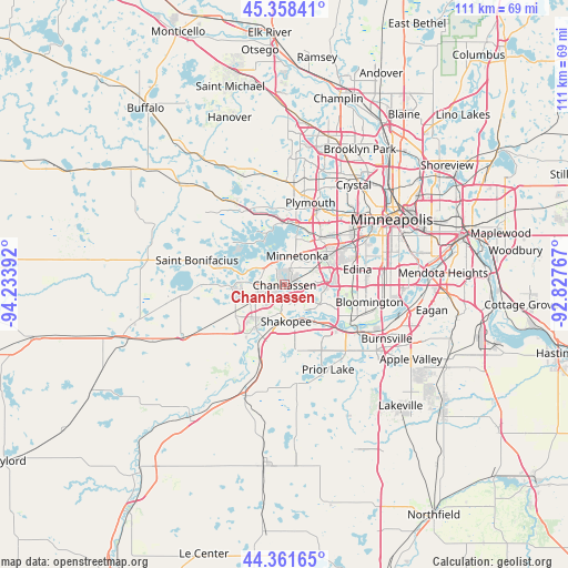
Chanhassen GPS coordinates[2]
44° 51' 43.884" North, 93° 31' 50.844" West
| Map corner | latitude | longitude |
|---|---|---|
| Upper-left | 45.35841°, | -94.23392° |
| Center: | 44.86219°, | -93.53079° |
| Lower-right: | 44.36165°, | -92.82767° |
| Map W x H: | 110.8×110.8 km | = 68.8×68.8mi |
| max Lat: | 71.29058° ⇑8.1% North |
| Chanhassen: | 44.86219° |
| min Lat: | ⇓91.9% South 19.06759° |
| min Long | Chanhassen | max Long |
| -171.73463° | -93.53079° | -66.98998° |
| W 32.4%⇐ | ⇒67.6% E |
Elevation
Elevation of Chanhassen is 296 m = 971 ft, and this is 1.2 m = 4 ft above average elevation for this country.
| Max E: |
3189 m = 10463 ft | 28% |
| Chanhassen | 296 m 971 ft | |
| Avg. | 294.8 m = 967 ft | |
Min E: |
-60 m = -197 ft | 72% |
See also: United States elevation on elevation.city.
Geographical zone
Chanhassen is located in North temperate zone (between Tropic of Cancer and the Arctic Circle). Distance of this Northern Tropic circle is 2382.3 km =1480.3 mi to South.| Distance of | km | miles | from Chanhassen |
|---|---|---|---|
| North Pole | 5018.9 | 3118.6 | to North |
| Arctic Circle | 2413 | 1499.4 | to North |
| Tropic Cancer | 2382.3 | 1480.3 | to South |
| Equator | 4988.2 | 3099.5 | to South |


Nearby cities:
15 places around Chanhassen: (largest is in red/bold)
• Chaska
9.9 km =6.2 mi,  214°
214°
• Deephaven
7.5 km =4.7 mi,  4°
4°
• Eden Prairie
4.8 km =3 mi,  100°
100°
• Excelsior
5.4 km =3.4 mi,  328°
328°
• Greenwood
6.1 km =3.8 mi,  343°
343°
• Hopkins
8.8 km =5.5 mi,  37°
37°
• Minnetonka
6.1 km =3.8 mi,  20°
20°
• Minnetonka Beach
9.3 km =5.8 mi, 337°
• Minnetonka Mills
11.2 km =7 mi, 38°
• Shakopee
7.1 km =4.4 mi,  177°
177°
• Shorewood
6.3 km =3.9 mi,  313°
313°
• Spring Park
11.4 km =7.1 mi,  315°
315°
• Tonka Bay
7.1 km =4.4 mi, 316°
• Victoria
10.3 km =6.4 mi,  267°
267°
• Wayzata
12.6 km =7.8 mi,  8°
8°
Sources, notices
• [Note1] Compared only with cities in United States existing in our database
• [Src1] Map data: © OpenStreetMap contributors (CC-BY-SA)
• [Src2] Other city data from geonames.org with taken over terms of usage.
• [Src3] Geographical zone / Annual Mean Temperature by Robert A. Rohde @ Wikipedia
