Shakopee geodata
Shakopee (Minnesota) is a seat of a second-order administrative division; located in United States in America/Chicago (GMT-5) time zone. With population of 39,981 people, there are 1210 cities with bigger population in this country. Compared to other cities in United States, 91.6% of cities are located further ↓South; 67.6% of cities are located further →East and 56.9% of cities have lower elevation than Shakopee. Note1


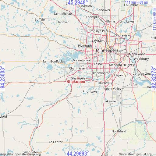
Shakopee GPS coordinates[2]
44° 47' 52.872" North, 93° 31' 36.84" West
| Map corner | latitude | longitude |
|---|---|---|
| Upper-left | 45.2948°, | -94.23003° |
| Center: | 44.79802°, | -93.5269° |
| Lower-right: | 44.29693°, | -92.82378° |
| Map W x H: | 111×111 km | = 69×69mi |
| max Lat: | 71.29058° ⇑8.4% North |
| Shakopee: | 44.79802° |
| min Lat: | ⇓91.6% South 19.06759° |
| min Long | Shakopee | max Long |
| -171.73463° | -93.5269° | -66.98998° |
| W 32.4%⇐ | ⇒67.6% E |
Elevation
Elevation of Shakopee is 226 m = 741 ft, and this is 68.8 m = 226 ft below average elevation for this country.
| Max E: |
3189 m = 10463 ft | 43.1% |
| Avg. | 294.8 m = 967 ft | |
| Shakopee | 226 m = 741 ft | |
Min E: |
-60 m = -197 ft | 56.9% |
See also: United States elevation on elevation.city.
Geographical zone
Shakopee is located in North temperate zone (between Tropic of Cancer and the Arctic Circle). Distance of this Northern Tropic circle is 2375.2 km =1475.9 mi to South.| Distance of | km | miles | from Shakopee |
|---|---|---|---|
| North Pole | 5026 | 3123 | to North |
| Arctic Circle | 2420.1 | 1503.8 | to North |
| Tropic Cancer | 2375.2 | 1475.9 | to South |
| Equator | 4981.1 | 3095.1 | to South |


Nearby cities:
15 places around Shakopee: (largest is in red/bold)
• Carver
8.7 km =5.4 mi,  243°
243°
• Chanhassen
7.1 km =4.4 mi,  357°
357°
• Chaska
6 km =3.7 mi,  260°
260°
• Deephaven
14.6 km =9.1 mi,  1°
1°
• Eden Prairie
7.7 km =4.8 mi,  35°
35°
• Excelsior
12.1 km =7.5 mi,  345°
345°
• Greenwood
13.2 km =8.2 mi, 350°
• Hopkins
15 km =9.3 mi,  19°
19°
• Minnetonka
13 km =8.1 mi,  8°
8°
• Minnetonka Beach
16.2 km =10.1 mi, 346°
• Prior Lake
12.5 km =7.8 mi,  138°
138°
• Savage
15.2 km =9.4 mi,  97°
97°
• Shorewood
12.4 km =7.7 mi,  336°
336°
• Tonka Bay
13.4 km =8.3 mi, 337°
• Victoria
12.6 km =7.8 mi,  302°
302°
Sources, notices
• [Note1] Compared only with cities in United States existing in our database
• [Src1] Map data: © OpenStreetMap contributors (CC-BY-SA)
• [Src2] Other city data from geonames.org with taken over terms of usage.
• [Src3] Geographical zone / Annual Mean Temperature by Robert A. Rohde @ Wikipedia
