Elysian geodata
Elysian (Minnesota) is a populated place; located in United States in America/Chicago (GMT-5) time zone. With population of 669 people, there are 18982 cities with bigger population in this country. Compared to other cities in United States, 89.2% of cities are located further ↓South; 67.9% of cities are located further →East and 75.5% of cities have lower elevation than Elysian. Note1


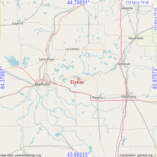
Elysian GPS coordinates[2]
44° 11' 54.888" North, 93° 40' 25.824" West
| Map corner | latitude | longitude |
|---|---|---|
| Upper-left | 44.70051°, | -94.37697° |
| Center: | 44.19858°, | -93.67384° |
| Lower-right: | 43.69233°, | -92.97072° |
| Map W x H: | 112.1×112.1 km | = 69.7×69.7mi |
| max Lat: | 71.29058° ⇑10.8% North |
| Elysian: | 44.19858° |
| min Lat: | ⇓89.2% South 19.06759° |
| min Long | Elysian | max Long |
| -171.73463° | -93.67384° | -66.98998° |
| W 32.1%⇐ | ⇒67.9% E |
Elevation
Elevation of Elysian is 317 m = 1040 ft, and this is 22.2 m = 73 ft above average elevation for this country.
| Max E: |
3189 m = 10463 ft | 24.5% |
| Elysian | 317 m 1040 ft | |
| Avg. | 294.8 m = 967 ft | |
Min E: |
-60 m = -197 ft | 75.5% |
See also: United States elevation on elevation.city.
Geographical zone
Elysian is located in North temperate zone (between Tropic of Cancer and the Arctic Circle). Distance of this Northern Tropic circle is 2308.5 km =1434.4 mi to South.| Distance of | km | miles | from Elysian |
|---|---|---|---|
| North Pole | 5092.6 | 3164.4 | to North |
| Arctic Circle | 2486.8 | 1545.2 | to North |
| Tropic Cancer | 2308.5 | 1434.4 | to South |
| Equator | 4914.4 | 3053.7 | to South |


Nearby cities:
15 places around Elysian: (largest is in red/bold)
• Cleveland
19.2 km =11.9 mi,  317°
317°
• Eagle Lake
17 km =10.6 mi,  257°
257°
• Janesville
9.6 km =6 mi,  196°
196°
• Kasota
25.4 km =15.8 mi,  294°
294°
• Le Center
21.7 km =13.5 mi,  348°
348°
• Madison Lake
11.3 km =7 mi,  273°
273°
• Mankato
27.1 km =16.8 mi, 260°
• Montgomery
27.7 km =17.2 mi,  15°
15°
• Morristown
18.5 km =11.5 mi,  80°
80°
• North Mankato
28.8 km =17.9 mi, 264°
• Saint Clair
19.6 km =12.2 mi,  228°
228°
• Saint Peter
26.6 km =16.5 mi,  301°
301°
• Warsaw
23 km =14.3 mi, 75°
• Waseca
18.9 km =11.7 mi,  135°
135°
• Waterville
8.7 km =5.4 mi, 75°
Sources, notices
• [Note1] Compared only with cities in United States existing in our database
• [Src1] Map data: © OpenStreetMap contributors (CC-BY-SA)
• [Src2] Other city data from geonames.org with taken over terms of usage.
• [Src3] Geographical zone / Annual Mean Temperature by Robert A. Rohde @ Wikipedia
