Lyle geodata
Lyle (Minnesota) is a populated place; located in United States in America/Chicago (GMT-5) time zone. With population of 542 people, there are 20368 cities with bigger population in this country. Compared to other cities in United States, 86.4% of cities are located further ↓South; 66.1% of cities are located further →East and 81.3% of cities have lower elevation than Lyle. Note1


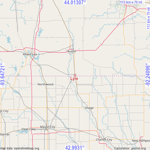
Lyle GPS coordinates[2]
43° 30' 18.864" North, 92° 56' 38.688" West
| Map corner | latitude | longitude |
|---|---|---|
| Upper-left | 44.01307°, | -93.64721° |
| Center: | 43.50524°, | -92.94408° |
| Lower-right: | 42.9931°, | -92.24096° |
| Map W x H: | 113.4×113.4 km | = 70.5×70.5mi |
| max Lat: | 71.29058° ⇑13.6% North |
| Lyle: | 43.50524° |
| min Lat: | ⇓86.4% South 19.06759° |
| min Long | Lyle | max Long |
| -171.73463° | -92.94408° | -66.98998° |
| W 33.9%⇐ | ⇒66.1% E |
Elevation
Elevation of Lyle is 368 m = 1207 ft, and this is 73.2 m = 240 ft above average elevation for this country.
| Max E: |
3189 m = 10463 ft | 18.7% |
| Lyle | 368 m 1207 ft | |
| Avg. | 294.8 m = 967 ft | |
Min E: |
-60 m = -197 ft | 81.3% |
See also: United States elevation on elevation.city.
Geographical zone
Lyle is located in North temperate zone (between Tropic of Cancer and the Arctic Circle). Distance of this Northern Tropic circle is 2231.4 km =1386.5 mi to South.| Distance of | km | miles | from Lyle |
|---|---|---|---|
| North Pole | 5169.7 | 3212.3 | to North |
| Arctic Circle | 2563.8 | 1593.1 | to North |
| Tropic Cancer | 2231.4 | 1386.5 | to South |
| Equator | 4837.3 | 3005.8 | to South |


Nearby cities:
15 places around Lyle: (largest is in red/bold)
• Adams
19.3 km =12 mi,  69°
69°
• Albert Lea
37.7 km =23.4 mi,  294°
294°
• Austin
18.1 km =11.2 mi,  352°
352°
• Blooming Prairie
41.1 km =25.5 mi, 347°
• Brownsdale
26.8 km =16.7 mi,  12°
12°
• Clarks Grove
42.3 km =26.3 mi,  312°
312°
• Glenville
28.2 km =17.5 mi, 285°
• Grand Meadow
37.3 km =23.2 mi,  53°
53°
• Le Roy
35.5 km =22.1 mi,  89°
89°
• Manly
32 km =19.9 mi,  220°
220°
• Nora Springs
40.6 km =25.2 mi,  186°
186°
• Northwood
23.4 km =14.5 mi,  253°
253°
• Osage
26.8 km =16.7 mi,  156°
156°
• Riceville
35.2 km =21.9 mi,  116°
116°
• Saint Ansgar
14.3 km =8.9 mi,  171°
171°
Sources, notices
• [Note1] Compared only with cities in United States existing in our database
• [Src1] Map data: © OpenStreetMap contributors (CC-BY-SA)
• [Src2] Other city data from geonames.org with taken over terms of usage.
• [Src3] Geographical zone / Annual Mean Temperature by Robert A. Rohde @ Wikipedia
