Austin geodata
Austin (Minnesota) is a seat of a second-order administrative division; located in United States in America/Chicago (GMT-5) time zone. With population of 24,563 people, there are 2056 cities with bigger population in this country. Compared to other cities in United States, 87.1% of cities are located further ↓South; 66.2% of cities are located further →East and 81.5% of cities have lower elevation than Austin. Note1


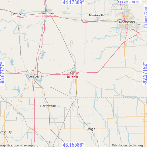
Austin GPS coordinates[2]
43° 39' 59.868" North, 92° 58' 28.704" West
| Map corner | latitude | longitude |
|---|---|---|
| Upper-left | 44.17309°, | -93.67777° |
| Center: | 43.66663°, | -92.97464° |
| Lower-right: | 43.15586°, | -92.27152° |
| Map W x H: | 113.1×113.1 km | = 70.3×70.3mi |
| max Lat: | 71.29058° ⇑12.9% North |
| Austin: | 43.66663° |
| min Lat: | ⇓87.1% South 19.06759° |
| min Long | Austin | max Long |
| -171.73463° | -92.97464° | -66.98998° |
| W 33.8%⇐ | ⇒66.2% E |
Elevation
Elevation of Austin is 370 m = 1214 ft, and this is 75.2 m = 247 ft above average elevation for this country.
| Max E: |
3189 m = 10463 ft | 18.5% |
| Austin | 370 m 1214 ft | |
| Avg. | 294.8 m = 967 ft | |
Min E: |
-60 m = -197 ft | 81.5% |
See also: United States elevation on elevation.city.
Geographical zone
Austin is located in North temperate zone (between Tropic of Cancer and the Arctic Circle). Distance of this Northern Tropic circle is 2249.4 km =1397.7 mi to South.| Distance of | km | miles | from Austin |
|---|---|---|---|
| North Pole | 5151.8 | 3201.2 | to North |
| Arctic Circle | 2545.9 | 1581.9 | to North |
| Tropic Cancer | 2249.4 | 1397.7 | to South |
| Equator | 4855.3 | 3016.9 | to South |


Nearby cities:
15 places around Austin: (largest is in red/bold)
• Adams
23.4 km =14.5 mi,  118°
118°
• Albert Lea
31.7 km =19.7 mi,  266°
266°
• Blooming Prairie
23.1 km =14.4 mi,  344°
344°
• Brownsdale
11.8 km =7.3 mi,  45°
45°
• Clarks Grove
30.5 km =19 mi,  290°
290°
• Dodge Center
41.3 km =25.7 mi,  13°
13°
• Ellendale
34.8 km =21.6 mi,  311°
311°
• Geneva
29.3 km =18.2 mi, 306°
• Glenville
26.8 km =16.7 mi,  247°
247°
• Grand Meadow
32.7 km =20.3 mi,  82°
82°
• Hayfield
26.9 km =16.7 mi,  22°
22°
• Lyle
18.1 km =11.2 mi,  172°
172°
• Northwood
31.7 km =19.7 mi,  218°
218°
• Racine
41.3 km =25.7 mi,  72°
72°
• Saint Ansgar
32.4 km =20.1 mi, 172°
Sources, notices
• [Note1] Compared only with cities in United States existing in our database
• [Src1] Map data: © OpenStreetMap contributors (CC-BY-SA)
• [Src2] Other city data from geonames.org with taken over terms of usage.
• [Src3] Geographical zone / Annual Mean Temperature by Robert A. Rohde @ Wikipedia
