Saint Paul Park geodata
Saint Paul Park (Minnesota) is a populated place; located in United States in America/Chicago (GMT-5) time zone. With population of 5,279 people, there are 6933 cities with bigger population in this country. Compared to other cities in United States, 91.8% of cities are located further ↓South; 66.2% of cities are located further →East and 59.4% of cities have lower elevation than Saint Paul Park. Note1
Administrative division(s):
- Level 1: Minnesota
- Level 2: Washington County
- Level 3: City of Saint Paul Park


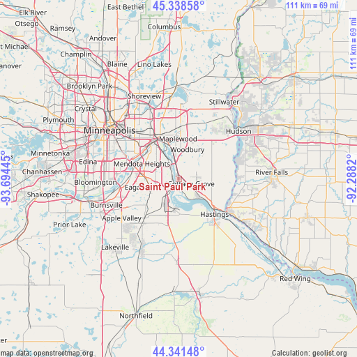
Saint Paul Park GPS coordinates[2]
44° 50' 31.884" North, 92° 59' 28.752" West
| Map corner | latitude | longitude |
|---|---|---|
| Upper-left | 45.33858°, | -93.69445° |
| Center: | 44.84219°, | -92.99132° |
| Lower-right: | 44.34148°, | -92.2882° |
| Map W x H: | 110.9×110.9 km | = 68.9×68.9mi |
| max Lat: | 71.29058° ⇑8.2% North |
| Saint Paul Park: | 44.84219° |
| min Lat: | ⇓91.8% South 19.06759° |
| min Long | Saint Paul Park | max Long |
| -171.73463° | -92.99132° | -66.98998° |
| W 33.8%⇐ | ⇒66.2% E |
Elevation
Elevation of Saint Paul Park is 237 m = 778 ft, and this is 57.8 m = 190 ft below average elevation for this country.
| Max E: |
3189 m = 10463 ft | 40.6% |
| Avg. | 294.8 m = 967 ft | |
| Saint Paul Park | 237 m = 778 ft | |
Min E: |
-60 m = -197 ft | 59.4% |
See also: United States elevation on elevation.city.
Geographical zone
Saint Paul Park is located in North temperate zone (between Tropic of Cancer and the Arctic Circle). Distance of this Northern Tropic circle is 2380.1 km =1478.9 mi to South.| Distance of | km | miles | from Saint Paul Park |
|---|---|---|---|
| North Pole | 5021.1 | 3120 | to North |
| Arctic Circle | 2415.2 | 1500.7 | to North |
| Tropic Cancer | 2380.1 | 1478.9 | to South |
| Equator | 4986 | 3098.2 | to South |


Nearby cities:
15 places around Saint Paul Park: (largest is in red/bold)
• Cottage Grove
4.1 km =2.5 mi,  113°
113°
• Eagan
14.5 km =9 mi,  253°
253°
• Hastings
15.5 km =9.6 mi,  135°
135°
• Inver Grove Heights
4.1 km =2.5 mi,  279°
279°
• Landfall
12.1 km =7.5 mi,  5°
5°
• Lilydale
13.4 km =8.3 mi,  307°
307°
• Maplewood
12.3 km =7.6 mi,  358°
358°
• Mendota Heights
12.5 km =7.8 mi,  291°
291°
• Newport
2.8 km =1.7 mi,  344°
344°
• Oakdale
13.6 km =8.5 mi, 8°
• Saint Paul
13.9 km =8.6 mi,  324°
324°
• South Saint Paul
6.6 km =4.1 mi,  328°
328°
• Sunfish Lake
9 km =5.6 mi, 290°
• West Saint Paul
12 km =7.5 mi, 313°
• Woodbury
9.4 km =5.8 mi,  15°
15°
Sources, notices
• [Note1] Compared only with cities in United States existing in our database
• [Src1] Map data: © OpenStreetMap contributors (CC-BY-SA)
• [Src2] Other city data from geonames.org with taken over terms of usage.
• [Src3] Geographical zone / Annual Mean Temperature by Robert A. Rohde @ Wikipedia
