Moorhead geodata
Moorhead (Minnesota) is a seat of a second-order administrative division; located in United States in America/Chicago (GMT-5) time zone. With population of 42,005 people, there are 1141 cities with bigger population in this country. Compared to other cities in United States, 96.4% of cities are located further ↓South; 75.1% of cities are located further →East and 67.4% of cities have lower elevation than Moorhead. Note1


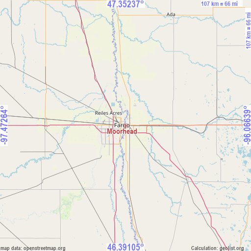
Moorhead GPS coordinates[2]
46° 52' 25.896" North, 96° 46' 10.236" West
| Map corner | latitude | longitude |
|---|---|---|
| Upper-left | 47.35237°, | -97.47264° |
| Center: | 46.87386°, | -96.76951° |
| Lower-right: | 46.39105°, | -96.06639° |
| Map W x H: | 106.9×106.9 km | = 66.4×66.4mi |
| max Lat: | 71.29058° ⇑3.6% North |
| Moorhead: | 46.87386° |
| min Lat: | ⇓96.4% South 19.06759° |
| min Long | Moorhead | max Long |
| -171.73463° | -96.76951° | -66.98998° |
| W 24.9%⇐ | ⇒75.1% E |
Elevation
Elevation of Moorhead is 273 m = 896 ft, and this is 21.8 m = 72 ft below average elevation for this country.
| Max E: |
3189 m = 10463 ft | 32.6% |
| Avg. | 294.8 m = 967 ft | |
| Moorhead | 273 m = 896 ft | |
Min E: |
-60 m = -197 ft | 67.4% |
See also: Moorhead elevation on elevation.city.
Geographical zone
Moorhead is located in North temperate zone (between Tropic of Cancer and the Arctic Circle). Distance of this North polar circle is 2189.3 km =1360.4 mi to North.| Distance of | km | miles | from Moorhead |
|---|---|---|---|
| North Pole | 4795.2 | 2979.6 | to North |
| Arctic Circle | 2189.3 | 1360.4 | to North |
| Tropic Cancer | 2606 | 1619.3 | to South |
| Equator | 5211.9 | 3238.5 | to South |


Nearby cities:
15 places around Moorhead: (largest is in red/bold)
• Barnesville
36.3 km =22.6 mi,  132°
132°
• Casselton
33.7 km =20.9 mi,  275°
275°
• Dilworth
5 km =3.1 mi,  86°
86°
• Fargo
1.6 km =1 mi, 283°
• Glyndon
14.5 km =9 mi, 89°
• Harwood
14.5 km =9 mi,  324°
324°
• Hawley
34.4 km =21.4 mi, 88°
• Horace
16.4 km =10.2 mi,  218°
218°
• Kindred
31.4 km =19.5 mi, 216°
• Mapleton
21.6 km =13.4 mi,  274°
274°
• Oakport
6.5 km =4 mi,  353°
353°
• Reiles Acres
9.1 km =5.7 mi,  306°
306°
• Sabin
13.7 km =8.5 mi,  139°
139°
• Ulen
44.9 km =27.9 mi,  59°
59°
• West Fargo
9.9 km =6.2 mi, 270°
Sources, notices
• [Note1] Compared only with cities in United States existing in our database
• [Src1] Map data: © OpenStreetMap contributors (CC-BY-SA)
• [Src2] Other city data from geonames.org with taken over terms of usage.
• [Src3] Geographical zone / Annual Mean Temperature by Robert A. Rohde @ Wikipedia
