Fargo geodata
Fargo (North Dakota) is a seat of a second-order administrative division; located in United States in America/Chicago (GMT-5) time zone. With population of 118,523 people, there are 266 cities with bigger population in this country. Compared to other cities in United States, 96.4% of cities are located further ↓South; 75.2% of cities are located further →East and 68.7% of cities have lower elevation than Fargo. Note1


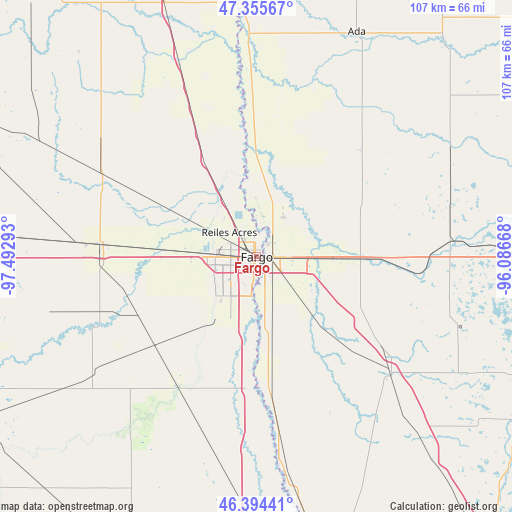
Fargo GPS coordinates[2]
46° 52' 37.884" North, 96° 47' 23.28" West
| Map corner | latitude | longitude |
|---|---|---|
| Upper-left | 47.35567°, | -97.49293° |
| Center: | 46.87719°, | -96.7898° |
| Lower-right: | 46.39441°, | -96.08668° |
| Map W x H: | 106.9×106.9 km | = 66.4×66.4mi |
| max Lat: | 71.29058° ⇑3.6% North |
| Fargo: | 46.87719° |
| min Lat: | ⇓96.4% South 19.06759° |
| min Long | Fargo | max Long |
| -171.73463° | -96.7898° | -66.98998° |
| W 24.8%⇐ | ⇒75.2% E |
Elevation
Elevation of Fargo is 279 m = 915 ft, and this is 15.8 m = 52 ft below average elevation for this country.
| Max E: |
3189 m = 10463 ft | 31.3% |
| Avg. | 294.8 m = 967 ft | |
| Fargo | 279 m = 915 ft | |
Min E: |
-60 m = -197 ft | 68.7% |
See also: Fargo elevation on elevation.city.
Geographical zone
Fargo is located in North temperate zone (between Tropic of Cancer and the Arctic Circle). Distance of this North polar circle is 2188.9 km =1360.1 mi to North.| Distance of | km | miles | from Fargo |
|---|---|---|---|
| North Pole | 4794.8 | 2979.3 | to North |
| Arctic Circle | 2188.9 | 1360.1 | to North |
| Tropic Cancer | 2606.3 | 1619.5 | to South |
| Equator | 5212.3 | 3238.8 | to South |


Nearby cities:
15 places around Fargo: (largest is in red/bold)
• Barnesville
37.7 km =23.4 mi,  131°
131°
• Casselton
32.1 km =19.9 mi,  274°
274°
• Dilworth
6.6 km =4.1 mi,  90°
90°
• Glyndon
16 km =9.9 mi, 90°
• Harwood
13.3 km =8.3 mi,  328°
328°
• Hawley
36 km =22.4 mi, 89°
• Horace
15.8 km =9.8 mi,  213°
213°
• Kindred
30.8 km =19.1 mi, 214°
• Mapleton
20 km =12.4 mi, 273°
• Moorhead
1.6 km =1 mi,  103°
103°
• Oakport
6.1 km =3.8 mi,  7°
7°
• Reiles Acres
7.7 km =4.8 mi,  311°
311°
• Sabin
15 km =9.3 mi,  136°
136°
• Ulen
46.1 km =28.6 mi,  60°
60°
• West Fargo
8.4 km =5.2 mi, 268°
Sources, notices
• [Note1] Compared only with cities in United States existing in our database
• [Src1] Map data: © OpenStreetMap contributors (CC-BY-SA)
• [Src2] Other city data from geonames.org with taken over terms of usage.
• [Src3] Geographical zone / Annual Mean Temperature by Robert A. Rohde @ Wikipedia
