Barnesville geodata
Barnesville (Minnesota) is a populated place; located in United States in America/Chicago (GMT-5) time zone. With population of 2,577 people, there are 10440 cities with bigger population in this country. Compared to other cities in United States, 96.1% of cities are located further ↓South; 74.3% of cities are located further →East and 74.7% of cities have lower elevation than Barnesville. Note1


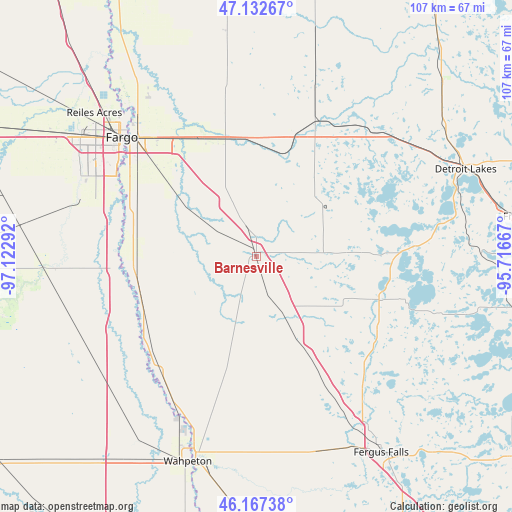
Barnesville GPS coordinates[2]
46° 39' 7.848" North, 96° 25' 11.244" West
| Map corner | latitude | longitude |
|---|---|---|
| Upper-left | 47.13267°, | -97.12292° |
| Center: | 46.65218°, | -96.41979° |
| Lower-right: | 46.16738°, | -95.71667° |
| Map W x H: | 107.3×107.3 km | = 66.7×66.7mi |
| max Lat: | 71.29058° ⇑3.9% North |
| Barnesville: | 46.65218° |
| min Lat: | ⇓96.1% South 19.06759° |
| min Long | Barnesville | max Long |
| -171.73463° | -96.41979° | -66.98998° |
| W 25.7%⇐ | ⇒74.3% E |
Elevation
Elevation of Barnesville is 311 m = 1020 ft, and this is 16.2 m = 53 ft above average elevation for this country.
| Max E: |
3189 m = 10463 ft | 25.3% |
| Barnesville | 311 m 1020 ft | |
| Avg. | 294.8 m = 967 ft | |
Min E: |
-60 m = -197 ft | 74.7% |
See also: United States elevation on elevation.city.
Geographical zone
Barnesville is located in North temperate zone (between Tropic of Cancer and the Arctic Circle). Distance of this North polar circle is 2213.9 km =1375.7 mi to North.| Distance of | km | miles | from Barnesville |
|---|---|---|---|
| North Pole | 4819.8 | 2994.9 | to North |
| Arctic Circle | 2213.9 | 1375.7 | to North |
| Tropic Cancer | 2581.3 | 1603.9 | to South |
| Equator | 5187.2 | 3223.2 | to South |


Nearby cities:
15 places around Barnesville: (largest is in red/bold)
• Audubon
40.8 km =25.4 mi,  54°
54°
• Breckenridge
45.1 km =28 mi,  196°
196°
• Dilworth
33 km =20.5 mi,  319°
319°
• Fargo
37.7 km =23.4 mi,  311°
311°
• Glyndon
27.6 km =17.1 mi,  333°
333°
• Hawley
26.6 km =16.5 mi,  17°
17°
• Horace
38.8 km =24.1 mi,  287°
287°
• Lake Park
35.9 km =22.3 mi,  43°
43°
• Moorhead
36.3 km =22.6 mi, 312°
• Oakport
41.4 km =25.7 mi, 318°
• Pelican Rapids
27.3 km =17 mi,  109°
109°
• Reiles Acres
45.4 km =28.2 mi, 311°
• Sabin
22.7 km =14.1 mi, 308°
• Wahpeton
45.3 km =28.1 mi, 198°
• West Fargo
44.2 km =27.5 mi,  304°
304°
Sources, notices
• [Note1] Compared only with cities in United States existing in our database
• [Src1] Map data: © OpenStreetMap contributors (CC-BY-SA)
• [Src2] Other city data from geonames.org with taken over terms of usage.
• [Src3] Geographical zone / Annual Mean Temperature by Robert A. Rohde @ Wikipedia
