Sabin geodata
Sabin (Minnesota) is a populated place; located in United States in America/Chicago (GMT-5) time zone. With population of 551 people, there are 20264 cities with bigger population in this country. Compared to other cities in United States, 96.3% of cities are located further ↓South; 74.8% of cities are located further →East and 69.5% of cities have lower elevation than Sabin. Note1


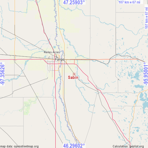
Sabin GPS coordinates[2]
46° 46' 46.848" North, 96° 39' 11.268" West
| Map corner | latitude | longitude |
|---|---|---|
| Upper-left | 47.25903°, | -97.35626° |
| Center: | 46.77968°, | -96.65313° |
| Lower-right: | 46.29602°, | -95.95001° |
| Map W x H: | 107.1×107.1 km | = 66.5×66.5mi |
| max Lat: | 71.29058° ⇑3.7% North |
| Sabin: | 46.77968° |
| min Lat: | ⇓96.3% South 19.06759° |
| min Long | Sabin | max Long |
| -171.73463° | -96.65313° | -66.98998° |
| W 25.2%⇐ | ⇒74.8% E |
Elevation
Elevation of Sabin is 283 m = 928 ft, and this is 11.8 m = 39 ft below average elevation for this country.
| Max E: |
3189 m = 10463 ft | 30.5% |
| Avg. | 294.8 m = 967 ft | |
| Sabin | 283 m = 928 ft | |
Min E: |
-60 m = -197 ft | 69.5% |
See also: United States elevation on elevation.city.
Geographical zone
Sabin is located in North temperate zone (between Tropic of Cancer and the Arctic Circle). Distance of this North polar circle is 2199.8 km =1366.9 mi to North.| Distance of | km | miles | from Sabin |
|---|---|---|---|
| North Pole | 4805.6 | 2986.1 | to North |
| Arctic Circle | 2199.8 | 1366.9 | to North |
| Tropic Cancer | 2595.5 | 1612.8 | to South |
| Equator | 5201.4 | 3232 | to South |


Nearby cities:
15 places around Sabin: (largest is in red/bold)
• Barnesville
22.7 km =14.1 mi,  128°
128°
• Casselton
44.5 km =27.7 mi,  287°
287°
• Dilworth
11.4 km =7.1 mi,  340°
340°
• Fargo
15 km =9.3 mi,  316°
316°
• Glyndon
12 km =7.5 mi,  27°
27°
• Harwood
28.1 km =17.5 mi, 322°
• Hawley
28 km =17.4 mi,  66°
66°
• Horace
19.2 km =11.9 mi,  263°
263°
• Kindred
31.3 km =19.4 mi,  242°
242°
• Lake Park
44.1 km =27.4 mi, 74°
• Mapleton
32.7 km =20.3 mi, 291°
• Moorhead
13.7 km =8.5 mi, 319°
• Oakport
19.4 km =12.1 mi,  330°
330°
• Reiles Acres
22.7 km =14.1 mi,  314°
314°
• West Fargo
21.6 km =13.4 mi,  299°
299°
Sources, notices
• [Note1] Compared only with cities in United States existing in our database
• [Src1] Map data: © OpenStreetMap contributors (CC-BY-SA)
• [Src2] Other city data from geonames.org with taken over terms of usage.
• [Src3] Geographical zone / Annual Mean Temperature by Robert A. Rohde @ Wikipedia
