Mazeppa geodata
Mazeppa (Minnesota) is a populated place; located in United States in America/Chicago (GMT-5) time zone. With population of 822 people, there are 17600 cities with bigger population in this country. Compared to other cities in United States, 89.5% of cities are located further ↓South; 65.3% of cities are located further →East and 70.9% of cities have lower elevation than Mazeppa. Note1


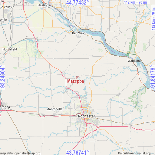
Mazeppa GPS coordinates[2]
44° 16' 22.872" North, 92° 32' 41.676" West
| Map corner | latitude | longitude |
|---|---|---|
| Upper-left | 44.77432°, | -93.24804° |
| Center: | 44.27302°, | -92.54491° |
| Lower-right: | 43.76741°, | -91.84179° |
| Map W x H: | 112×112 km | = 69.6×69.6mi |
| max Lat: | 71.29058° ⇑10.5% North |
| Mazeppa: | 44.27302° |
| min Lat: | ⇓89.5% South 19.06759° |
| min Long | Mazeppa | max Long |
| -171.73463° | -92.54491° | -66.98998° |
| W 34.7%⇐ | ⇒65.3% E |
Elevation
Elevation of Mazeppa is 290 m = 951 ft, and this is 4.8 m = 16 ft below average elevation for this country.
| Max E: |
3189 m = 10463 ft | 29.1% |
| Avg. | 294.8 m = 967 ft | |
| Mazeppa | 290 m = 951 ft | |
Min E: |
-60 m = -197 ft | 70.9% |
See also: United States elevation on elevation.city.
Geographical zone
Mazeppa is located in North temperate zone (between Tropic of Cancer and the Arctic Circle). Distance of this Northern Tropic circle is 2316.8 km =1439.6 mi to South.| Distance of | km | miles | from Mazeppa |
|---|---|---|---|
| North Pole | 5084.4 | 3159.3 | to North |
| Arctic Circle | 2478.5 | 1540.1 | to North |
| Tropic Cancer | 2316.8 | 1439.6 | to South |
| Equator | 4922.7 | 3058.8 | to South |


Nearby cities:
15 places around Mazeppa: (largest is in red/bold)
• Byron
27.9 km =17.3 mi,  196°
196°
• Elgin
28.3 km =17.6 mi,  124°
124°
• Goodhue
15.5 km =9.6 mi,  336°
336°
• Kasson
31.6 km =19.6 mi,  211°
211°
• Kenyon
35.1 km =21.8 mi,  269°
269°
• Lake City
29.5 km =18.3 mi,  48°
48°
• Mantorville
28.2 km =17.5 mi,  216°
216°
• Oronoco
11.9 km =7.4 mi,  176°
176°
• Pine Island
11.3 km =7 mi,  225°
225°
• Plainview
32.1 km =19.9 mi,  111°
111°
• Red Wing
32.2 km =20 mi,  1°
1°
• Rochester
28.6 km =17.8 mi,  167°
167°
• Wanamingo
19.9 km =12.4 mi,  280°
280°
• West Concord
31.2 km =19.4 mi,  244°
244°
• Zumbrota
10.2 km =6.3 mi, 283°
Sources, notices
• [Note1] Compared only with cities in United States existing in our database
• [Src1] Map data: © OpenStreetMap contributors (CC-BY-SA)
• [Src2] Other city data from geonames.org with taken over terms of usage.
• [Src3] Geographical zone / Annual Mean Temperature by Robert A. Rohde @ Wikipedia
