Rollingstone geodata
Rollingstone (Minnesota) is a populated place; located in United States in America/Chicago (GMT-5) time zone. With population of 657 people, there are 19109 cities with bigger population in this country. Compared to other cities in United States, 88.8% of cities are located further ↓South; 63.7% of cities are located further →East and 57.7% of cities have lower elevation than Rollingstone. Note1


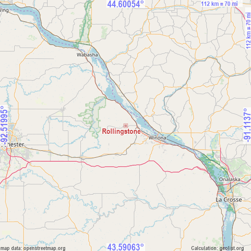
Rollingstone GPS coordinates[2]
44° 5' 51.864" North, 91° 49' 0.552" West
| Map corner | latitude | longitude |
|---|---|---|
| Upper-left | 44.60054°, | -92.51995° |
| Center: | 44.09774°, | -91.81682° |
| Lower-right: | 43.59063°, | -91.1137° |
| Map W x H: | 112.3×112.3 km | = 69.8×69.8mi |
| max Lat: | 71.29058° ⇑11.2% North |
| Rollingstone: | 44.09774° |
| min Lat: | ⇓88.8% South 19.06759° |
| min Long | Rollingstone | max Long |
| -171.73463° | -91.81682° | -66.98998° |
| W 36.3%⇐ | ⇒63.7% E |
Elevation
Elevation of Rollingstone is 229 m = 751 ft, and this is 65.8 m = 216 ft below average elevation for this country.
| Max E: |
3189 m = 10463 ft | 42.3% |
| Avg. | 294.8 m = 967 ft | |
| Rollingstone | 229 m = 751 ft | |
Min E: |
-60 m = -197 ft | 57.7% |
See also: United States elevation on elevation.city.
Geographical zone
Rollingstone is located in North temperate zone (between Tropic of Cancer and the Arctic Circle). Distance of this Northern Tropic circle is 2297.3 km =1427.5 mi to South.| Distance of | km | miles | from Rollingstone |
|---|---|---|---|
| North Pole | 5103.9 | 3171.4 | to North |
| Arctic Circle | 2498 | 1552.2 | to North |
| Tropic Cancer | 2297.3 | 1427.5 | to South |
| Equator | 4903.2 | 3046.7 | to South |


Nearby cities:
15 places around Rollingstone: (largest is in red/bold)
• Alma
25.9 km =16.1 mi,  342°
342°
• Arcadia
30.5 km =19 mi,  55°
55°
• Buffalo City
15.2 km =9.4 mi,  345°
345°
• Dover
29.2 km =18.1 mi,  241°
241°
• Elgin
34.9 km =21.7 mi,  275°
275°
• Fountain City
8.7 km =5.4 mi, 64°
• Goodview
10.4 km =6.5 mi,  112°
112°
• Lewiston
13.3 km =8.3 mi,  198°
198°
• Plainview
29.3 km =18.2 mi, 284°
• Rushford
32.6 km =20.3 mi,  170°
170°
• Rushford Village
32.4 km =20.1 mi,  176°
176°
• Saint Charles
24.4 km =15.2 mi,  234°
234°
• Stockton
8.7 km =5.4 mi,  154°
154°
• Trempealeau
31.7 km =19.7 mi, 108°
• Winona
15.1 km =9.4 mi, 110°
Sources, notices
• [Note1] Compared only with cities in United States existing in our database
• [Src1] Map data: © OpenStreetMap contributors (CC-BY-SA)
• [Src2] Other city data from geonames.org with taken over terms of usage.
• [Src3] Geographical zone / Annual Mean Temperature by Robert A. Rohde @ Wikipedia
