Savage geodata
Savage (Minnesota) is a populated place; located in United States in America/Chicago (GMT-5) time zone. With population of 30,391 people, there are 1648 cities with bigger population in this country. Compared to other cities in United States, 91.5% of cities are located further ↓South; 67.1% of cities are located further →East and 54.4% of cities have lower elevation than Savage. Note1


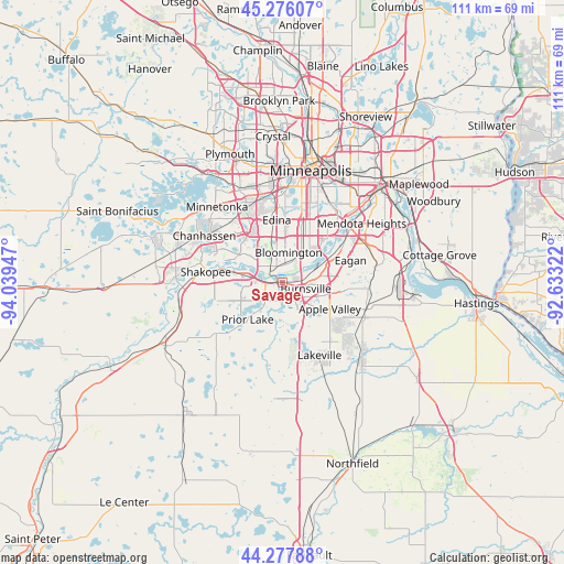
Savage GPS coordinates[2]
44° 46' 44.868" North, 93° 20' 10.824" West
| Map corner | latitude | longitude |
|---|---|---|
| Upper-left | 45.27607°, | -94.03947° |
| Center: | 44.77913°, | -93.33634° |
| Lower-right: | 44.27788°, | -92.63322° |
| Map W x H: | 111×111 km | = 69×69mi |
| max Lat: | 71.29058° ⇑8.5% North |
| Savage: | 44.77913° |
| min Lat: | ⇓91.5% South 19.06759° |
| min Long | Savage | max Long |
| -171.73463° | -93.33634° | -66.98998° |
| W 32.9%⇐ | ⇒67.1% E |
Elevation
Elevation of Savage is 216 m = 709 ft, and this is 78.8 m = 259 ft below average elevation for this country.
| Max E: |
3189 m = 10463 ft | 45.6% |
| Avg. | 294.8 m = 967 ft | |
| Savage | 216 m = 709 ft | |
Min E: |
-60 m = -197 ft | 54.4% |
See also: United States elevation on elevation.city.
Geographical zone
Savage is located in North temperate zone (between Tropic of Cancer and the Arctic Circle). Distance of this Northern Tropic circle is 2373.1 km =1474.6 mi to South.| Distance of | km | miles | from Savage |
|---|---|---|---|
| North Pole | 5028.1 | 3124.3 | to North |
| Arctic Circle | 2422.2 | 1505.1 | to North |
| Tropic Cancer | 2373.1 | 1474.6 | to South |
| Equator | 4979 | 3093.8 | to South |


Nearby cities:
15 places around Savage: (largest is in red/bold)
• Apple Valley
10.7 km =6.6 mi,  119°
119°
• Bloomington
7.5 km =4.7 mi,  23°
23°
• Burnsville
4.8 km =3 mi,  105°
105°
• Chanhassen
17.9 km =11.1 mi,  301°
301°
• Eagan
13.7 km =8.5 mi,  78°
78°
• Eden Prairie
13.5 km =8.4 mi,  308°
308°
• Edina
12.3 km =7.6 mi,  355°
355°
• Hopkins
19 km =11.8 mi,  328°
328°
• Lakeville
16.2 km =10.1 mi,  152°
152°
• Mendota Heights
19.5 km =12.1 mi,  53°
53°
• Prior Lake
10 km =6.2 mi,  222°
222°
• Richfield
12.3 km =7.6 mi, 19°
• Rosemount
17.2 km =10.7 mi,  104°
104°
• Saint Louis Park
18.8 km =11.7 mi, 357°
• Shakopee
15.2 km =9.4 mi,  277°
277°
Sources, notices
• [Note1] Compared only with cities in United States existing in our database
• [Src1] Map data: © OpenStreetMap contributors (CC-BY-SA)
• [Src2] Other city data from geonames.org with taken over terms of usage.
• [Src3] Geographical zone / Annual Mean Temperature by Robert A. Rohde @ Wikipedia
