Vineland geodata
Vineland (Minnesota) is a populated place; located in United States in America/Chicago (GMT-5) time zone. With population of 1,001 people, there are 16276 cities with bigger population in this country. Compared to other cities in United States, 95.3% of cities are located further ↓South; 68.1% of cities are located further →East and 82.4% of cities have lower elevation than Vineland. Note1
Administrative division(s):
- Level 1: Minnesota
- Level 2: Mille Lacs County
- Level 3: Township of Kathio


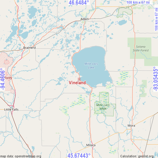
Vineland GPS coordinates[2]
46° 9' 48.852" North, 93° 45' 26.892" West
| Map corner | latitude | longitude |
|---|---|---|
| Upper-left | 46.6484°, | -94.4606° |
| Center: | 46.16357°, | -93.75747° |
| Lower-right: | 45.67443°, | -93.05435° |
| Map W x H: | 108.3×108.3 km | = 67.3×67.3mi |
| max Lat: | 71.29058° ⇑4.7% North |
| Vineland: | 46.16357° |
| min Lat: | ⇓95.3% South 19.06759° |
| min Long | Vineland | max Long |
| -171.73463° | -93.75747° | -66.98998° |
| W 31.9%⇐ | ⇒68.1% E |
Elevation
Elevation of Vineland is 381 m = 1250 ft, and this is 86.2 m = 283 ft above average elevation for this country.
| Max E: |
3189 m = 10463 ft | 17.6% |
| Vineland | 381 m 1250 ft | |
| Avg. | 294.8 m = 967 ft | |
Min E: |
-60 m = -197 ft | 82.4% |
See also: United States elevation on elevation.city.
Geographical zone
Vineland is located in North temperate zone (between Tropic of Cancer and the Arctic Circle). Distance of this North polar circle is 2268.3 km =1409.5 mi to North.| Distance of | km | miles | from Vineland |
|---|---|---|---|
| North Pole | 4874.2 | 3028.7 | to North |
| Arctic Circle | 2268.3 | 1409.5 | to North |
| Tropic Cancer | 2527 | 1570.2 | to South |
| Equator | 5132.9 | 3189.4 | to South |


Nearby cities:
15 places around Vineland: (largest is in red/bold)
• Aitkin
41.2 km =25.6 mi,  5°
5°
• Baxter
45.3 km =28.1 mi,  296°
296°
• Brainerd
40.4 km =25.1 mi, 302°
• Crosby
38.6 km =24 mi,  336°
336°
• Deerwood
36.1 km =22.4 mi, 342°
• East Gull Lake
53.4 km =33.2 mi, 300°
• Foreston
47.9 km =29.8 mi,  175°
175°
• Ironton
38.8 km =24.1 mi,  334°
334°
• Isle
22.3 km =13.9 mi,  97°
97°
• Little Falls
51.1 km =31.8 mi,  245°
245°
• Milaca
46 km =28.6 mi,  170°
170°
• Mora
47.9 km =29.8 mi,  131°
131°
• Onamia
12.4 km =7.7 mi,  146°
146°
• Pierz
33.6 km =20.9 mi,  232°
232°
• Royalton
55.6 km =34.5 mi, 228°
Sources, notices
• [Note1] Compared only with cities in United States existing in our database
• [Src1] Map data: © OpenStreetMap contributors (CC-BY-SA)
• [Src2] Other city data from geonames.org with taken over terms of usage.
• [Src3] Geographical zone / Annual Mean Temperature by Robert A. Rohde @ Wikipedia
