Walker geodata
Walker (Minnesota) is a seat of a second-order administrative division; located in United States in America/Chicago (GMT-5) time zone. With population of 928 people, there are 16810 cities with bigger population in this country. Compared to other cities in United States, 96.8% of cities are located further ↓South; 70.1% of cities are located further →East and 83.8% of cities have lower elevation than Walker. Note1


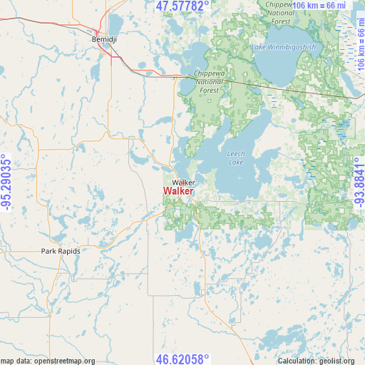
Walker GPS coordinates[2]
47° 6' 4.86" North, 94° 35' 13.992" West
| Map corner | latitude | longitude |
|---|---|---|
| Upper-left | 47.57782°, | -95.29035° |
| Center: | 47.10135°, | -94.58722° |
| Lower-right: | 46.62058°, | -93.8841° |
| Map W x H: | 106.4×106.4 km | = 66.1×66.1mi |
| max Lat: | 71.29058° ⇑3.2% North |
| Walker: | 47.10135° |
| min Lat: | ⇓96.8% South 19.06759° |
| min Long | Walker | max Long |
| -171.73463° | -94.58722° | -66.98998° |
| W 29.9%⇐ | ⇒70.1% E |
Elevation
Elevation of Walker is 402 m = 1319 ft, and this is 107.2 m = 352 ft above average elevation for this country.
| Max E: |
3189 m = 10463 ft | 16.2% |
| Walker | 402 m 1319 ft | |
| Avg. | 294.8 m = 967 ft | |
Min E: |
-60 m = -197 ft | 83.8% |
See also: United States elevation on elevation.city.
Geographical zone
Walker is located in North temperate zone (between Tropic of Cancer and the Arctic Circle). Distance of this North polar circle is 2164 km =1344.6 mi to North.| Distance of | km | miles | from Walker |
|---|---|---|---|
| North Pole | 4769.9 | 2963.9 | to North |
| Arctic Circle | 2164 | 1344.6 | to North |
| Tropic Cancer | 2631.3 | 1635 | to South |
| Equator | 5237.2 | 3254.2 | to South |


Nearby cities:
15 places around Walker: (largest is in red/bold)
• Bemidji
46.9 km =29.1 mi,  331°
331°
• Blackduck
70.3 km =43.7 mi,  2°
2°
• Breezy Point
63.4 km =39.4 mi,  153°
153°
• Cass Lake
30.9 km =19.2 mi,  357°
357°
• Cohasset
75.3 km =46.8 mi,  76°
76°
• Cross Lake
60.9 km =37.8 mi,  143°
143°
• Deer River
65.3 km =40.6 mi,  66°
66°
• Emily
63.1 km =39.2 mi,  130°
130°
• Lake Shore
70.6 km =43.9 mi,  165°
165°
• Menahga
54.8 km =34.1 mi,  225°
225°
• Nisswa
68.5 km =42.6 mi,  160°
160°
• Park Rapids
40.9 km =25.4 mi,  240°
240°
• Pequot Lakes
59.3 km =36.8 mi, 159°
• Pine River
44.8 km =27.8 mi, 161°
• Sebeka
64.8 km =40.3 mi,  216°
216°
Sources, notices
• [Note1] Compared only with cities in United States existing in our database
• [Src1] Map data: © OpenStreetMap contributors (CC-BY-SA)
• [Src2] Other city data from geonames.org with taken over terms of usage.
• [Src3] Geographical zone / Annual Mean Temperature by Robert A. Rohde @ Wikipedia
