Sebeka geodata
Sebeka (Minnesota) is a populated place; located in United States in America/Chicago (GMT-5) time zone. With population of 692 people, there are 18758 cities with bigger population in this country. Compared to other cities in United States, 96% of cities are located further ↓South; 71.3% of cities are located further →East and 84.8% of cities have lower elevation than Sebeka. Note1


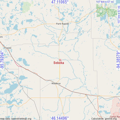
Sebeka GPS coordinates[2]
46° 37' 47.856" North, 95° 5' 20.076" West
| Map corner | latitude | longitude |
|---|---|---|
| Upper-left | 47.11065°, | -95.79204° |
| Center: | 46.62996°, | -95.08891° |
| Lower-right: | 46.14496°, | -94.38579° |
| Map W x H: | 107.4×107.4 km | = 66.7×66.7mi |
| max Lat: | 71.29058° ⇑4% North |
| Sebeka: | 46.62996° |
| min Lat: | ⇓96% South 19.06759° |
| min Long | Sebeka | max Long |
| -171.73463° | -95.08891° | -66.98998° |
| W 28.7%⇐ | ⇒71.3% E |
Elevation
Elevation of Sebeka is 420 m = 1378 ft, and this is 125.2 m = 411 ft above average elevation for this country.
| Max E: |
3189 m = 10463 ft | 15.2% |
| Sebeka | 420 m 1378 ft | |
| Avg. | 294.8 m = 967 ft | |
Min E: |
-60 m = -197 ft | 84.8% |
See also: United States elevation on elevation.city.
Geographical zone
Sebeka is located in North temperate zone (between Tropic of Cancer and the Arctic Circle). Distance of this North polar circle is 2216.4 km =1377.2 mi to North.| Distance of | km | miles | from Sebeka |
|---|---|---|---|
| North Pole | 4822.3 | 2996.4 | to North |
| Arctic Circle | 2216.4 | 1377.2 | to North |
| Tropic Cancer | 2578.8 | 1602.4 | to South |
| Equator | 5184.8 | 3221.7 | to South |


Nearby cities:
15 places around Sebeka: (largest is in red/bold)
• Clarissa
56.6 km =35.2 mi,  169°
169°
• Eagle Bend
51.8 km =32.2 mi,  175°
175°
• Frazee
47.9 km =29.8 mi,  283°
283°
• Henning
43.8 km =27.2 mi,  218°
218°
• Menahga
13.8 km =8.6 mi,  357°
357°
• Motley
47 km =29.2 mi,  133°
133°
• New York Mills
25.2 km =15.7 mi,  240°
240°
• Ottertail
42.4 km =26.3 mi, 237°
• Park Rapids
32.6 km =20.3 mi,  4°
4°
• Parkers Prairie
56.1 km =34.9 mi,  199°
199°
• Perham
37.2 km =23.1 mi,  263°
263°
• Pine River
53.2 km =33.1 mi,  79°
79°
• Staples
38 km =23.6 mi,  143°
143°
• Verndale
26.4 km =16.4 mi, 167°
• Wadena
21.2 km =13.2 mi,  189°
189°
Sources, notices
• [Note1] Compared only with cities in United States existing in our database
• [Src1] Map data: © OpenStreetMap contributors (CC-BY-SA)
• [Src2] Other city data from geonames.org with taken over terms of usage.
• [Src3] Geographical zone / Annual Mean Temperature by Robert A. Rohde @ Wikipedia
