Menahga geodata
Menahga (Minnesota) is a populated place; located in United States in America/Chicago (GMT-5) time zone. With population of 1,339 people, there are 14397 cities with bigger population in this country. Compared to other cities in United States, 96.2% of cities are located further ↓South; 71.3% of cities are located further →East and 85.2% of cities have lower elevation than Menahga. Note1


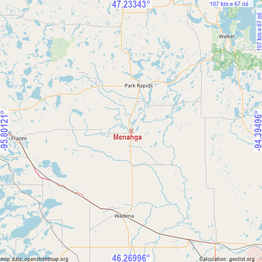
Menahga GPS coordinates[2]
46° 45' 13.86" North, 95° 5' 53.088" West
| Map corner | latitude | longitude |
|---|---|---|
| Upper-left | 47.23343°, | -95.80121° |
| Center: | 46.75385°, | -95.09808° |
| Lower-right: | 46.26996°, | -94.39496° |
| Map W x H: | 107.1×107.1 km | = 66.5×66.5mi |
| max Lat: | 71.29058° ⇑3.8% North |
| Menahga: | 46.75385° |
| min Lat: | ⇓96.2% South 19.06759° |
| min Long | Menahga | max Long |
| -171.73463° | -95.09808° | -66.98998° |
| W 28.7%⇐ | ⇒71.3% E |
Elevation
Elevation of Menahga is 428 m = 1404 ft, and this is 133.2 m = 437 ft above average elevation for this country.
| Max E: |
3189 m = 10463 ft | 14.8% |
| Menahga | 428 m 1404 ft | |
| Avg. | 294.8 m = 967 ft | |
Min E: |
-60 m = -197 ft | 85.2% |
See also: United States elevation on elevation.city.
Geographical zone
Menahga is located in North temperate zone (between Tropic of Cancer and the Arctic Circle). Distance of this North polar circle is 2202.6 km =1368.6 mi to North.| Distance of | km | miles | from Menahga |
|---|---|---|---|
| North Pole | 4808.5 | 2987.9 | to North |
| Arctic Circle | 2202.6 | 1368.6 | to North |
| Tropic Cancer | 2592.6 | 1611 | to South |
| Equator | 5198.5 | 3230.2 | to South |


Nearby cities:
15 places around Menahga: (largest is in red/bold)
• Detroit Lakes
57.3 km =35.6 mi,  277°
277°
• Frazee
46 km =28.6 mi,  266°
266°
• Henning
54.9 km =34.1 mi,  208°
208°
• Motley
57.9 km =36 mi,  143°
143°
• New York Mills
33.7 km =20.9 mi,  218°
218°
• Ottertail
50.6 km =31.4 mi, 223°
• Park Rapids
19 km =11.8 mi,  9°
9°
• Pequot Lakes
62.5 km =38.8 mi,  105°
105°
• Perham
40.3 km =25 mi,  243°
243°
• Pine River
53 km =32.9 mi,  94°
94°
• Sebeka
13.8 km =8.6 mi,  177°
177°
• Staples
50.1 km =31.1 mi,  152°
152°
• Verndale
40 km =24.9 mi,  170°
170°
• Wadena
34.7 km =21.6 mi, 184°
• Walker
54.8 km =34.1 mi,  45°
45°
Sources, notices
• [Note1] Compared only with cities in United States existing in our database
• [Src1] Map data: © OpenStreetMap contributors (CC-BY-SA)
• [Src2] Other city data from geonames.org with taken over terms of usage.
• [Src3] Geographical zone / Annual Mean Temperature by Robert A. Rohde @ Wikipedia
