Unionville geodata
Unionville (Missouri) is a seat of a second-order administrative division; located in United States in America/Chicago (GMT-5) time zone. With population of 1,815 people, there are 12486 cities with bigger population in this country. Compared to other cities in United States, 58.7% of cities are located further ↓South; 66.3% of cities are located further →East and 76.9% of cities have lower elevation than Unionville. Note1


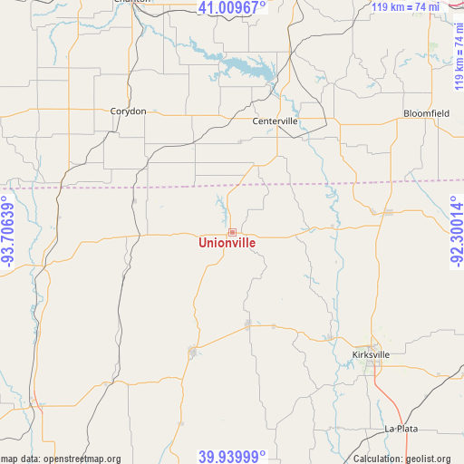
Unionville GPS coordinates[2]
40° 28' 37.056" North, 93° 0' 11.736" West
| Map corner | latitude | longitude |
|---|---|---|
| Upper-left | 41.00967°, | -93.70639° |
| Center: | 40.47696°, | -93.00326° |
| Lower-right: | 39.93999°, | -92.30014° |
| Map W x H: | 118.9×118.9 km | = 73.9×73.9mi |
| max Lat: | 71.29058° ⇑41.3% North |
| Unionville: | 40.47696° |
| min Lat: | ⇓58.7% South 19.06759° |
| min Long | Unionville | max Long |
| -171.73463° | -93.00326° | -66.98998° |
| W 33.7%⇐ | ⇒66.3% E |
Elevation
Elevation of Unionville is 327 m = 1073 ft, and this is 32.2 m = 106 ft above average elevation for this country.
| Max E: |
3189 m = 10463 ft | 23.1% |
| Unionville | 327 m 1073 ft | |
| Avg. | 294.8 m = 967 ft | |
Min E: |
-60 m = -197 ft | 76.9% |
See also: United States elevation on elevation.city.
Geographical zone
Unionville is located in North temperate zone (between Tropic of Cancer and the Arctic Circle). Distance of this Northern Tropic circle is 1894.7 km =1177.3 mi to South.| Distance of | km | miles | from Unionville |
|---|---|---|---|
| North Pole | 5506.4 | 3421.5 | to North |
| Arctic Circle | 2900.6 | 1802.3 | to North |
| Tropic Cancer | 1894.7 | 1177.3 | to South |
| Equator | 4500.6 | 2796.5 | to South |


Nearby cities:
15 places around Unionville: (largest is in red/bold)
• Albia
63.3 km =39.3 mi,  15°
15°
• Bloomfield
58.3 km =36.2 mi,  58°
58°
• Centerville
30.6 km =19 mi, 20°
• Corydon
41 km =25.5 mi,  319°
319°
• Green City
23.5 km =14.6 mi,  169°
169°
• Kirksville
47.5 km =29.5 mi,  131°
131°
• Lancaster
40.5 km =25.2 mi,  83°
83°
• Milan
32.2 km =20 mi,  198°
198°
• Moravia
48.7 km =30.3 mi, 19°
• Moulton
36 km =22.4 mi,  49°
49°
• Princeton
49.6 km =30.8 mi,  260°
260°
• Queen City
37.6 km =23.4 mi,  101°
101°
• Russell
58.5 km =36.4 mi,  343°
343°
• Seymour
24.9 km =15.5 mi, 336°
• Terre Haute
20 km =12.4 mi, 257°
Sources, notices
• [Note1] Compared only with cities in United States existing in our database
• [Src1] Map data: © OpenStreetMap contributors (CC-BY-SA)
• [Src2] Other city data from geonames.org with taken over terms of usage.
• [Src3] Geographical zone / Annual Mean Temperature by Robert A. Rohde @ Wikipedia
