Centerville geodata
Centerville (Iowa) is a seat of a second-order administrative division; located in United States in America/Chicago (GMT-5) time zone. With population of 5,372 people, there are 6862 cities with bigger population in this country. Compared to other cities in United States, 62.1% of cities are located further ↓South; 66% of cities are located further →East and 74.7% of cities have lower elevation than Centerville. Note1


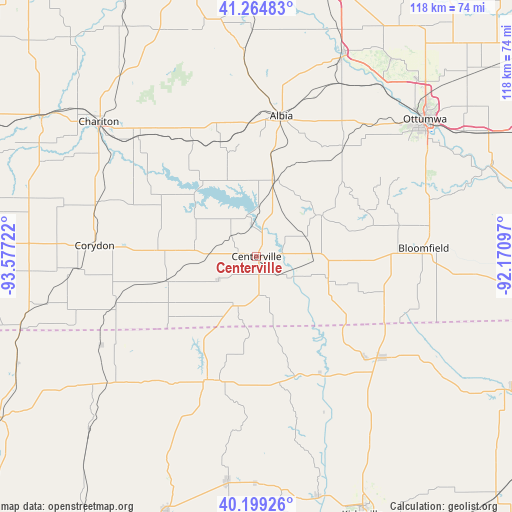
Centerville GPS coordinates[2]
40° 44' 3.048" North, 92° 52' 26.724" West
| Map corner | latitude | longitude |
|---|---|---|
| Upper-left | 41.26483°, | -93.57722° |
| Center: | 40.73418°, | -92.87409° |
| Lower-right: | 40.19926°, | -92.17097° |
| Map W x H: | 118.5×118.5 km | = 73.6×73.6mi |
| max Lat: | 71.29058° ⇑37.9% North |
| Centerville: | 40.73418° |
| min Lat: | ⇓62.1% South 19.06759° |
| min Long | Centerville | max Long |
| -171.73463° | -92.87409° | -66.98998° |
| W 34%⇐ | ⇒66% E |
Elevation
Elevation of Centerville is 311 m = 1020 ft, and this is 16.2 m = 53 ft above average elevation for this country.
| Max E: |
3189 m = 10463 ft | 25.3% |
| Centerville | 311 m 1020 ft | |
| Avg. | 294.8 m = 967 ft | |
Min E: |
-60 m = -197 ft | 74.7% |
See also: United States elevation on elevation.city.
Geographical zone
Centerville is located in North temperate zone (between Tropic of Cancer and the Arctic Circle). Distance of this Northern Tropic circle is 1923.3 km =1195.1 mi to South.| Distance of | km | miles | from Centerville |
|---|---|---|---|
| North Pole | 5477.8 | 3403.7 | to North |
| Arctic Circle | 2872 | 1784.6 | to North |
| Tropic Cancer | 1923.3 | 1195.1 | to South |
| Equator | 4529.2 | 2814.3 | to South |


Nearby cities:
15 places around Centerville: (largest is in red/bold)
• Albia
33 km =20.5 mi,  10°
10°
• Bloomfield
38.7 km =24 mi,  87°
87°
• Chariton
47.8 km =29.7 mi,  310°
310°
• Corydon
37.5 km =23.3 mi,  273°
273°
• Eddyville
51 km =31.7 mi,  22°
22°
• Lancaster
37.6 km =23.4 mi,  129°
129°
• Lovilia
44.7 km =27.8 mi,  356°
356°
• Moravia
18.1 km =11.2 mi, 15°
• Moulton
17.4 km =10.8 mi,  107°
107°
• Ottumwa
50.2 km =31.2 mi,  50°
50°
• Queen City
44.4 km =27.6 mi,  144°
144°
• Russell
38.8 km =24.1 mi,  315°
315°
• Seymour
21.6 km =13.4 mi,  254°
254°
• Terre Haute
44.7 km =27.8 mi,  222°
222°
• Unionville
30.6 km =19 mi,  200°
200°
Sources, notices
• [Note1] Compared only with cities in United States existing in our database
• [Src1] Map data: © OpenStreetMap contributors (CC-BY-SA)
• [Src2] Other city data from geonames.org with taken over terms of usage.
• [Src3] Geographical zone / Annual Mean Temperature by Robert A. Rohde @ Wikipedia
