Albia geodata
Albia (Iowa) is a seat of a second-order administrative division; located in United States in America/Chicago (GMT-5) time zone. With population of 3,829 people, there are 8419 cities with bigger population in this country. Compared to other cities in United States, 66.2% of cities are located further ↓South; 65.9% of cities are located further →East and 71.3% of cities have lower elevation than Albia. Note1


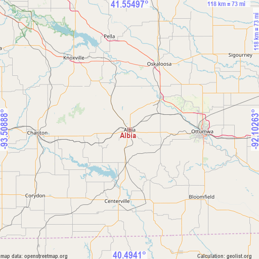
Albia GPS coordinates[2]
41° 1' 36.012" North, 92° 48' 20.7" West
| Map corner | latitude | longitude |
|---|---|---|
| Upper-left | 41.55497°, | -93.50888° |
| Center: | 41.02667°, | -92.80575° |
| Lower-right: | 40.4941°, | -92.10263° |
| Map W x H: | 118×118 km | = 73.3×73.3mi |
| max Lat: | 71.29058° ⇑33.8% North |
| Albia: | 41.02667° |
| min Lat: | ⇓66.2% South 19.06759° |
| min Long | Albia | max Long |
| -171.73463° | -92.80575° | -66.98998° |
| W 34.1%⇐ | ⇒65.9% E |
Elevation
Elevation of Albia is 292 m = 958 ft, and this is 2.8 m = 9 ft below average elevation for this country.
| Max E: |
3189 m = 10463 ft | 28.7% |
| Avg. | 294.8 m = 967 ft | |
| Albia | 292 m = 958 ft | |
Min E: |
-60 m = -197 ft | 71.3% |
See also: United States elevation on elevation.city.
Geographical zone
Albia is located in North temperate zone (between Tropic of Cancer and the Arctic Circle). Distance of this Northern Tropic circle is 1955.8 km =1215.3 mi to South.| Distance of | km | miles | from Albia |
|---|---|---|---|
| North Pole | 5445.3 | 3383.6 | to North |
| Arctic Circle | 2839.4 | 1764.3 | to North |
| Tropic Cancer | 1955.8 | 1215.3 | to South |
| Equator | 4561.7 | 2834.5 | to South |


Nearby cities:
15 places around Albia: (largest is in red/bold)
• Agency
42 km =26.1 mi,  94°
94°
• Centerville
33 km =20.5 mi,  190°
190°
• Chariton
42 km =26.1 mi,  268°
268°
• Eddyville
20.2 km =12.6 mi,  44°
44°
• Fremont
37.3 km =23.2 mi,  56°
56°
• Hedrick
44.7 km =27.8 mi,  68°
68°
• Knoxville
41.4 km =25.7 mi,  322°
322°
• Lovilia
14.7 km =9.1 mi,  325°
325°
• Melcher-Dallas
42.6 km =26.5 mi,  301°
301°
• Moravia
15.1 km =9.4 mi,  183°
183°
• Moulton
39.4 km =24.5 mi,  164°
164°
• Oskaloosa
32.9 km =20.4 mi,  24°
24°
• Ottumwa
33.1 km =20.6 mi, 91°
• Pella
43.4 km =27 mi,  347°
347°
• Russell
33.3 km =20.7 mi,  261°
261°
Sources, notices
• [Note1] Compared only with cities in United States existing in our database
• [Src1] Map data: © OpenStreetMap contributors (CC-BY-SA)
• [Src2] Other city data from geonames.org with taken over terms of usage.
• [Src3] Geographical zone / Annual Mean Temperature by Robert A. Rohde @ Wikipedia
