Sheldon geodata
Sheldon (North Dakota) is a seat of a third-order administrative division; located in United States in America/Chicago (GMT-5) time zone. With population of 124 people, there are 21032 cities with bigger population in this country. Compared to other cities in United States, 96% of cities are located further ↓South; 77.1% of cities are located further →East and 77.2% of cities have lower elevation than Sheldon. Note1
Administrative division(s):
- Level 1: North Dakota
- Level 2: Ransom County
- Level 3: Village of Sheldon


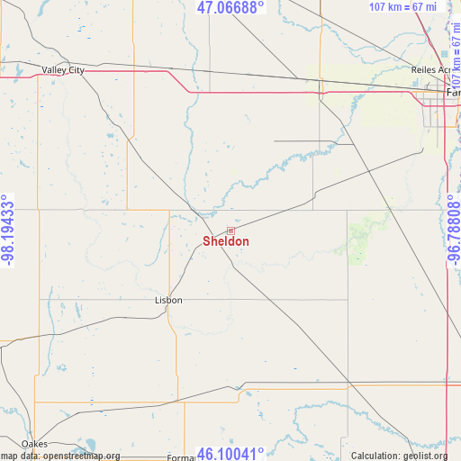
Sheldon GPS coordinates[2]
46° 35' 8.88" North, 97° 29' 28.32" West
| Map corner | latitude | longitude |
|---|---|---|
| Upper-left | 47.06688°, | -98.19433° |
| Center: | 46.5858°, | -97.4912° |
| Lower-right: | 46.10041°, | -96.78808° |
| Map W x H: | 107.5×107.5 km | = 66.8×66.8mi |
| max Lat: | 71.29058° ⇑4% North |
| Sheldon: | 46.5858° |
| min Lat: | ⇓96% South 19.06759° |
| min Long | Sheldon | max Long |
| -171.73463° | -97.4912° | -66.98998° |
| W 22.9%⇐ | ⇒77.1% E |
Elevation
Elevation of Sheldon is 329 m = 1079 ft, and this is 34.2 m = 112 ft above average elevation for this country.
| Max E: |
3189 m = 10463 ft | 22.8% |
| Sheldon | 329 m 1079 ft | |
| Avg. | 294.8 m = 967 ft | |
Min E: |
-60 m = -197 ft | 77.2% |
See also: United States elevation on elevation.city.
Geographical zone
Sheldon is located in North temperate zone (between Tropic of Cancer and the Arctic Circle). Distance of this North polar circle is 2221.3 km =1380.3 mi to North.| Distance of | km | miles | from Sheldon |
|---|---|---|---|
| North Pole | 4827.2 | 2999.5 | to North |
| Arctic Circle | 2221.3 | 1380.3 | to North |
| Tropic Cancer | 2573.9 | 1599.3 | to South |
| Equator | 5179.9 | 3218.6 | to South |


Nearby cities:
15 places around Sheldon: (largest is in red/bold)
• Casselton
41 km =25.5 mi,  31°
31°
• Enderlin
9.4 km =5.8 mi,  296°
296°
• Fargo
62.5 km =38.8 mi,  58°
58°
• Forman
54.3 km =33.7 mi,  191°
191°
• Gwinner
42.1 km =26.2 mi,  198°
198°
• Horace
48.8 km =30.3 mi,  66°
66°
• Kindred
36.9 km =22.9 mi,  79°
79°
• Lidgerwood
62.4 km =38.8 mi,  155°
155°
• Lisbon
21.6 km =13.4 mi,  222°
222°
• Mapleton
47.5 km =29.5 mi,  44°
44°
• Milnor
36.4 km =22.6 mi,  175°
175°
• Moorhead
63.6 km =39.5 mi, 59°
• Reiles Acres
60.7 km =37.7 mi,  51°
51°
• Valley City
54.1 km =33.6 mi,  313°
313°
• West Fargo
55.3 km =34.4 mi, 54°
Sources, notices
• [Note1] Compared only with cities in United States existing in our database
• [Src1] Map data: © OpenStreetMap contributors (CC-BY-SA)
• [Src2] Other city data from geonames.org with taken over terms of usage.
• [Src3] Geographical zone / Annual Mean Temperature by Robert A. Rohde @ Wikipedia
