Burwell geodata
Burwell (Nebraska) is a seat of a second-order administrative division; located in United States in America/Chicago (GMT-5) time zone. With population of 1,211 people, there are 15068 cities with bigger population in this country. Compared to other cities in United States, 73.7% of cities are located further ↓South; 80% of cities are located further →East and 90.5% of cities have lower elevation than Burwell. Note1


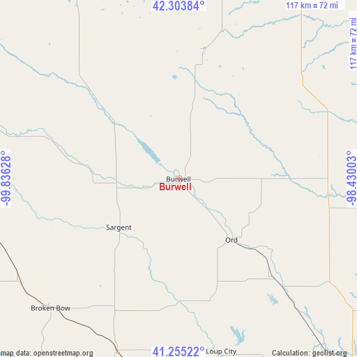
Burwell GPS coordinates[2]
41° 46' 54.012" North, 99° 7' 59.34" West
| Map corner | latitude | longitude |
|---|---|---|
| Upper-left | 42.30384°, | -99.83628° |
| Center: | 41.78167°, | -99.13315° |
| Lower-right: | 41.25522°, | -98.43003° |
| Map W x H: | 116.6×116.6 km | = 72.5×72.5mi |
| max Lat: | 71.29058° ⇑26.3% North |
| Burwell: | 41.78167° |
| min Lat: | ⇓73.7% South 19.06759° |
| min Long | Burwell | max Long |
| -171.73463° | -99.13315° | -66.98998° |
| W 20%⇐ | ⇒80% E |
Elevation
Elevation of Burwell is 664 m = 2178 ft, and this is 369.2 m = 1211 ft above average elevation for this country.
| Max E: |
3189 m = 10463 ft | 9.5% |
| Burwell | 664 m 2178 ft | |
| Avg. | 294.8 m = 967 ft | |
Min E: |
-60 m = -197 ft | 90.5% |
See also: United States elevation on elevation.city.
Geographical zone
Burwell is located in North temperate zone (between Tropic of Cancer and the Arctic Circle). Distance of this Northern Tropic circle is 2039.8 km =1267.5 mi to South.| Distance of | km | miles | from Burwell |
|---|---|---|---|
| North Pole | 5361.4 | 3331.4 | to North |
| Arctic Circle | 2755.5 | 1712.2 | to North |
| Tropic Cancer | 2039.8 | 1267.5 | to South |
| Equator | 4645.7 | 2886.7 | to South |


Nearby cities:
15 places around Burwell: (largest is in red/bold)
• Atkinson
84.3 km =52.4 mi,  8°
8°
• Bartlett
49.5 km =30.8 mi,  76°
76°
• Brewster
63.1 km =39.2 mi,  286°
286°
• Broken Bow
59.6 km =37 mi,  224°
224°
• Callaway
85.3 km =53 mi,  230°
230°
• Elgin
89.7 km =55.7 mi, 75°
• Greeley
56.3 km =35 mi,  117°
117°
• Loup City
58 km =36 mi,  166°
166°
• O'Neill
85.2 km =52.9 mi,  28°
28°
• Ord
26.2 km =16.3 mi,  139°
139°
• Ravenna
86 km =53.4 mi, 167°
• Saint Paul
84.5 km =52.5 mi, 138°
• Sargent
25.2 km =15.7 mi, 231°
• Stuart
90.9 km =56.5 mi,  359°
359°
• Taylor
20.4 km =12.7 mi,  266°
266°
Sources, notices
• [Note1] Compared only with cities in United States existing in our database
• [Src1] Map data: © OpenStreetMap contributors (CC-BY-SA)
• [Src2] Other city data from geonames.org with taken over terms of usage.
• [Src3] Geographical zone / Annual Mean Temperature by Robert A. Rohde @ Wikipedia
