Saint Paul geodata
Saint Paul (Nebraska) is a seat of a second-order administrative division; located in United States in America/Chicago (GMT-5) time zone. With population of 2,290 people, there are 11105 cities with bigger population in this country. Compared to other cities in United States, 67.9% of cities are located further ↓South; 79.3% of cities are located further →East and 88.9% of cities have lower elevation than Saint Paul. Note1


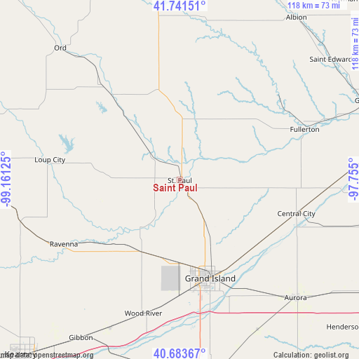
Saint Paul GPS coordinates[2]
41° 12' 53.028" North, 98° 27' 29.232" West
| Map corner | latitude | longitude |
|---|---|---|
| Upper-left | 41.74151°, | -99.16125° |
| Center: | 41.21473°, | -98.45812° |
| Lower-right: | 40.68367°, | -97.755° |
| Map W x H: | 117.6×117.6 km | = 73.1×73.1mi |
| max Lat: | 71.29058° ⇑32.1% North |
| Saint Paul: | 41.21473° |
| min Lat: | ⇓67.9% South 19.06759° |
| min Long | Saint Paul | max Long |
| -171.73463° | -98.45812° | -66.98998° |
| W 20.7%⇐ | ⇒79.3% E |
Elevation
Elevation of Saint Paul is 555 m = 1821 ft, and this is 260.2 m = 854 ft above average elevation for this country.
| Max E: |
3189 m = 10463 ft | 11.1% |
| Saint Paul | 555 m 1821 ft | |
| Avg. | 294.8 m = 967 ft | |
Min E: |
-60 m = -197 ft | 88.9% |
See also: United States elevation on elevation.city.
Geographical zone
Saint Paul is located in North temperate zone (between Tropic of Cancer and the Arctic Circle). Distance of this Northern Tropic circle is 1976.7 km =1228.3 mi to South.| Distance of | km | miles | from Saint Paul |
|---|---|---|---|
| North Pole | 5424.4 | 3370.6 | to North |
| Arctic Circle | 2818.5 | 1751.3 | to North |
| Tropic Cancer | 1976.7 | 1228.3 | to South |
| Equator | 4582.6 | 2847.5 | to South |


Nearby cities:
15 places around Saint Paul: (largest is in red/bold)
• Alda
38.2 km =23.7 mi,  181°
181°
• Aurora
54.2 km =33.7 mi,  135°
135°
• Cairo
26.8 km =16.7 mi,  207°
207°
• Central City
39.8 km =24.7 mi,  106°
106°
• Doniphan
49.8 km =30.9 mi,  171°
171°
• Fullerton
44.1 km =27.4 mi,  67°
67°
• Gibbon
61.2 km =38 mi, 212°
• Grand Island
33.7 km =20.9 mi,  163°
163°
• Greeley
37.6 km =23.4 mi,  350°
350°
• Loup City
43.1 km =26.8 mi,  279°
279°
• Ord
58.2 km =36.2 mi,  317°
317°
• Ravenna
43.5 km =27 mi,  241°
241°
• Saint Edward
63.3 km =39.3 mi,  51°
51°
• Shelton
53.6 km =33.3 mi, 205°
• Wood River
45.4 km =28.2 mi,  195°
195°
Sources, notices
• [Note1] Compared only with cities in United States existing in our database
• [Src1] Map data: © OpenStreetMap contributors (CC-BY-SA)
• [Src2] Other city data from geonames.org with taken over terms of usage.
• [Src3] Geographical zone / Annual Mean Temperature by Robert A. Rohde @ Wikipedia
