Clay Center geodata
Clay Center (Nebraska) is a seat of a second-order administrative division; located in United States in America/Chicago (GMT-5) time zone. With population of 730 people, there are 18398 cities with bigger population in this country. Compared to other cities in United States, 59.1% of cities are located further ↓South; 78.6% of cities are located further →East and 88.8% of cities have lower elevation than Clay Center. Note1


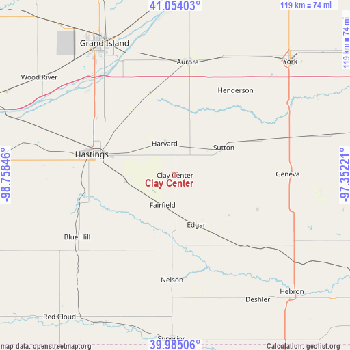
Clay Center GPS coordinates[2]
40° 31' 18.048" North, 98° 3' 19.188" West
| Map corner | latitude | longitude |
|---|---|---|
| Upper-left | 41.05403°, | -98.75846° |
| Center: | 40.52168°, | -98.05533° |
| Lower-right: | 39.98506°, | -97.35221° |
| Map W x H: | 118.9×118.9 km | = 73.9×73.9mi |
| max Lat: | 71.29058° ⇑40.9% North |
| Clay Center: | 40.52168° |
| min Lat: | ⇓59.1% South 19.06759° |
| min Long | Clay Center | max Long |
| -171.73463° | -98.05533° | -66.98998° |
| W 21.4%⇐ | ⇒78.6% E |
Elevation
Elevation of Clay Center is 549 m = 1801 ft, and this is 254.2 m = 834 ft above average elevation for this country.
| Max E: |
3189 m = 10463 ft | 11.2% |
| Clay Center | 549 m 1801 ft | |
| Avg. | 294.8 m = 967 ft | |
Min E: |
-60 m = -197 ft | 88.8% |
See also: United States elevation on elevation.city.
Geographical zone
Clay Center is located in North temperate zone (between Tropic of Cancer and the Arctic Circle). Distance of this Northern Tropic circle is 1899.7 km =1180.4 mi to South.| Distance of | km | miles | from Clay Center |
|---|---|---|---|
| North Pole | 5501.5 | 3418.5 | to North |
| Arctic Circle | 2895.6 | 1799.2 | to North |
| Tropic Cancer | 1899.7 | 1180.4 | to South |
| Equator | 4505.6 | 2799.6 | to South |


Nearby cities:
15 places around Clay Center: (largest is in red/bold)
• Alda
52.2 km =32.4 mi,  318°
318°
• Aurora
38.7 km =24 mi,  6°
6°
• Blue Hill
39.4 km =24.5 mi,  237°
237°
• Deshler
50.9 km =31.6 mi,  146°
146°
• Doniphan
38.4 km =23.9 mi, 316°
• Fairmont
41.7 km =25.9 mi,  72°
72°
• Geneva
38.8 km =24.1 mi,  89°
89°
• Grand Island
50.9 km =31.6 mi,  331°
331°
• Harvard
11.4 km =7.1 mi,  341°
341°
• Hastings
29 km =18 mi,  284°
284°
• Henderson
35.3 km =21.9 mi,  35°
35°
• Juniata
38.8 km =24.1 mi, 281°
• Kenesaw
52.1 km =32.4 mi, 282°
• Nelson
35.6 km =22.1 mi,  181°
181°
• Sutton
19 km =11.8 mi,  60°
60°
Sources, notices
• [Note1] Compared only with cities in United States existing in our database
• [Src1] Map data: © OpenStreetMap contributors (CC-BY-SA)
• [Src2] Other city data from geonames.org with taken over terms of usage.
• [Src3] Geographical zone / Annual Mean Temperature by Robert A. Rohde @ Wikipedia
