Blue Hill geodata
Blue Hill (Nebraska) is a populated place; located in United States in America/Chicago (GMT-5) time zone. With population of 889 people, there are 17051 cities with bigger population in this country. Compared to other cities in United States, 57.1% of cities are located further ↓South; 79.3% of cities are located further →East and 89.7% of cities have lower elevation than Blue Hill. Note1


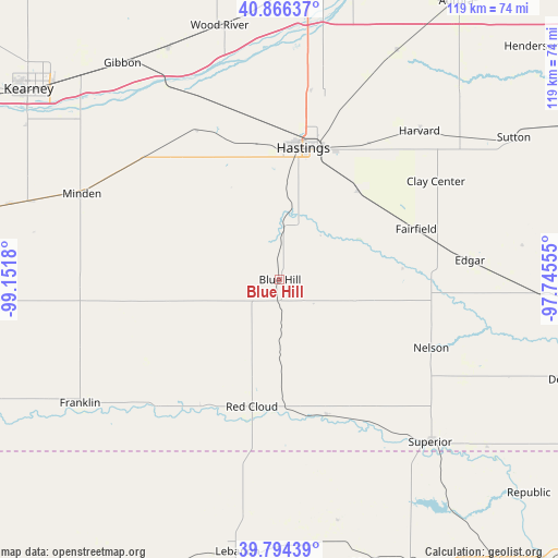
Blue Hill GPS coordinates[2]
40° 19' 57.036" North, 98° 26' 55.212" West
| Map corner | latitude | longitude |
|---|---|---|
| Upper-left | 40.86637°, | -99.1518° |
| Center: | 40.33251°, | -98.44867° |
| Lower-right: | 39.79439°, | -97.74555° |
| Map W x H: | 119.2×119.2 km | = 74.1×74.1mi |
| max Lat: | 71.29058° ⇑42.9% North |
| Blue Hill: | 40.33251° |
| min Lat: | ⇓57.1% South 19.06759° |
| min Long | Blue Hill | max Long |
| -171.73463° | -98.44867° | -66.98998° |
| W 20.7%⇐ | ⇒79.3% E |
Elevation
Elevation of Blue Hill is 604 m = 1982 ft, and this is 309.2 m = 1014 ft above average elevation for this country.
| Max E: |
3189 m = 10463 ft | 10.3% |
| Blue Hill | 604 m 1982 ft | |
| Avg. | 294.8 m = 967 ft | |
Min E: |
-60 m = -197 ft | 89.7% |
See also: United States elevation on elevation.city.
Geographical zone
Blue Hill is located in North temperate zone (between Tropic of Cancer and the Arctic Circle). Distance of this Northern Tropic circle is 1878.6 km =1167.3 mi to South.| Distance of | km | miles | from Blue Hill |
|---|---|---|---|
| North Pole | 5522.5 | 3431.5 | to North |
| Arctic Circle | 2916.6 | 1812.3 | to North |
| Tropic Cancer | 1878.6 | 1167.3 | to South |
| Equator | 4484.6 | 2786.6 | to South |


Nearby cities:
15 places around Blue Hill: (largest is in red/bold)
• Clay Center
39.4 km =24.5 mi,  57°
57°
• Doniphan
49.3 km =30.6 mi,  7°
7°
• Franklin
50.2 km =31.2 mi,  238°
238°
• Gibbon
57.1 km =35.5 mi,  324°
324°
• Harvard
43.6 km =27.1 mi,  43°
43°
• Hastings
28.7 km =17.8 mi, 10°
• Juniata
29 km =18 mi,  350°
350°
• Kenesaw
36.6 km =22.7 mi,  331°
331°
• Minden
46.1 km =28.6 mi,  293°
293°
• Nelson
35.4 km =22 mi,  114°
114°
• Red Cloud
27.7 km =17.2 mi,  192°
192°
• Shelton
55.1 km =34.2 mi, 334°
• Superior
47.3 km =29.4 mi,  137°
137°
• Sutton
58.4 km =36.3 mi, 58°
• Wood River
55.8 km =34.7 mi, 346°
Sources, notices
• [Note1] Compared only with cities in United States existing in our database
• [Src1] Map data: © OpenStreetMap contributors (CC-BY-SA)
• [Src2] Other city data from geonames.org with taken over terms of usage.
• [Src3] Geographical zone / Annual Mean Temperature by Robert A. Rohde @ Wikipedia
