Henderson geodata
Henderson (Nebraska) is a populated place; located in United States in America/Chicago (GMT-5) time zone. With population of 997 people, there are 16293 cities with bigger population in this country. Compared to other cities in United States, 62.8% of cities are located further ↓South; 78% of cities are located further →East and 88.4% of cities have lower elevation than Henderson. Note1


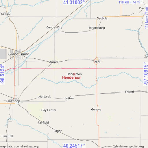
Henderson GPS coordinates[2]
40° 46' 47.028" North, 97° 48' 44.172" West
| Map corner | latitude | longitude |
|---|---|---|
| Upper-left | 41.31002°, | -98.5154° |
| Center: | 40.77973°, | -97.81227° |
| Lower-right: | 40.24517°, | -97.10915° |
| Map W x H: | 118.4×118.4 km | = 73.6×73.6mi |
| max Lat: | 71.29058° ⇑37.2% North |
| Henderson: | 40.77973° |
| min Lat: | ⇓62.8% South 19.06759° |
| min Long | Henderson | max Long |
| -171.73463° | -97.81227° | -66.98998° |
| W 22%⇐ | ⇒78% E |
Elevation
Elevation of Henderson is 527 m = 1729 ft, and this is 232.2 m = 762 ft above average elevation for this country.
| Max E: |
3189 m = 10463 ft | 11.6% |
| Henderson | 527 m 1729 ft | |
| Avg. | 294.8 m = 967 ft | |
Min E: |
-60 m = -197 ft | 88.4% |
See also: United States elevation on elevation.city.
Geographical zone
Henderson is located in North temperate zone (between Tropic of Cancer and the Arctic Circle). Distance of this Northern Tropic circle is 1928.4 km =1198.3 mi to South.| Distance of | km | miles | from Henderson |
|---|---|---|---|
| North Pole | 5472.8 | 3400.6 | to North |
| Arctic Circle | 2866.9 | 1781.4 | to North |
| Tropic Cancer | 1928.4 | 1198.3 | to South |
| Equator | 4534.3 | 2817.5 | to South |


Nearby cities:
15 places around Henderson: (largest is in red/bold)
• Aurora
18.9 km =11.7 mi,  301°
301°
• Central City
40.6 km =25.2 mi,  336°
336°
• Clay Center
35.3 km =21.9 mi,  215°
215°
• Doniphan
46.9 km =29.1 mi,  268°
268°
• Exeter
34 km =21.1 mi,  116°
116°
• Fairmont
24.9 km =15.5 mi,  129°
129°
• Friend
46.5 km =28.9 mi,  107°
107°
• Geneva
33.5 km =20.8 mi,  146°
146°
• Grand Island
47.4 km =29.5 mi,  289°
289°
• Harvard
29.9 km =18.6 mi,  233°
233°
• Osceola
49.7 km =30.9 mi,  26°
26°
• Stromsburg
41.3 km =25.7 mi, 25°
• Sutton
19.8 km =12.3 mi,  191°
191°
• Utica
41.4 km =25.7 mi,  71°
71°
• York
21 km =13 mi,  62°
62°
Sources, notices
• [Note1] Compared only with cities in United States existing in our database
• [Src1] Map data: © OpenStreetMap contributors (CC-BY-SA)
• [Src2] Other city data from geonames.org with taken over terms of usage.
• [Src3] Geographical zone / Annual Mean Temperature by Robert A. Rohde @ Wikipedia
