Sutton geodata
Sutton (Nebraska) is a populated place; located in United States in America/Chicago (GMT-5) time zone. With population of 1,440 people, there are 13919 cities with bigger population in this country. Compared to other cities in United States, 60.1% of cities are located further ↓South; 78.2% of cities are located further →East and 88.2% of cities have lower elevation than Sutton. Note1


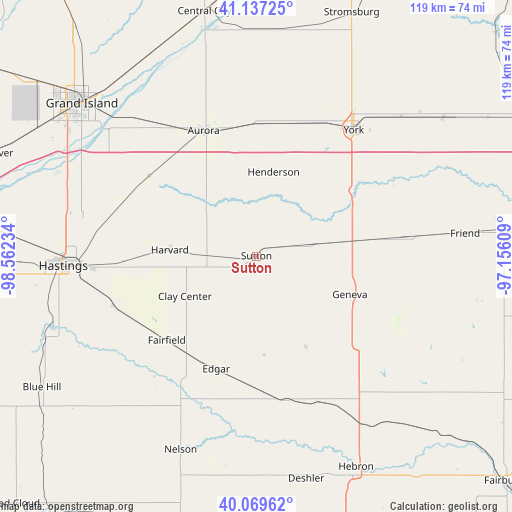
Sutton GPS coordinates[2]
40° 36' 20.052" North, 97° 51' 33.156" West
| Map corner | latitude | longitude |
|---|---|---|
| Upper-left | 41.13725°, | -98.56234° |
| Center: | 40.60557°, | -97.85921° |
| Lower-right: | 40.06962°, | -97.15609° |
| Map W x H: | 118.7×118.7 km | = 73.8×73.8mi |
| max Lat: | 71.29058° ⇑39.9% North |
| Sutton: | 40.60557° |
| min Lat: | ⇓60.1% South 19.06759° |
| min Long | Sutton | max Long |
| -171.73463° | -97.85921° | -66.98998° |
| W 21.8%⇐ | ⇒78.2% E |
Elevation
Elevation of Sutton is 513 m = 1683 ft, and this is 218.2 m = 716 ft above average elevation for this country.
| Max E: |
3189 m = 10463 ft | 11.8% |
| Sutton | 513 m 1683 ft | |
| Avg. | 294.8 m = 967 ft | |
Min E: |
-60 m = -197 ft | 88.2% |
See also: United States elevation on elevation.city.
Geographical zone
Sutton is located in North temperate zone (between Tropic of Cancer and the Arctic Circle). Distance of this Northern Tropic circle is 1909 km =1186.2 mi to South.| Distance of | km | miles | from Sutton |
|---|---|---|---|
| North Pole | 5492.1 | 3412.6 | to North |
| Arctic Circle | 2886.3 | 1793.5 | to North |
| Tropic Cancer | 1909 | 1186.2 | to South |
| Equator | 4514.9 | 2805.4 | to South |


Nearby cities:
15 places around Sutton: (largest is in red/bold)
• Aurora
31.6 km =19.6 mi,  337°
337°
• Clay Center
19 km =11.8 mi,  240°
240°
• Deshler
52.9 km =32.9 mi,  167°
167°
• Doniphan
46.8 km =29.1 mi,  293°
293°
• Exeter
34.8 km =21.6 mi,  82°
82°
• Fairmont
23.4 km =14.5 mi, 81°
• Friend
48.7 km =30.3 mi, 83°
• Geneva
23.9 km =14.9 mi,  111°
111°
• Harvard
20.1 km =12.5 mi,  274°
274°
• Hastings
44.7 km =27.8 mi, 267°
• Hebron
54 km =33.6 mi,  154°
154°
• Henderson
19.8 km =12.3 mi,  11°
11°
• Nelson
48.3 km =30 mi,  201°
201°
• Utica
54 km =33.6 mi,  53°
53°
• York
36.9 km =22.9 mi,  37°
37°
Sources, notices
• [Note1] Compared only with cities in United States existing in our database
• [Src1] Map data: © OpenStreetMap contributors (CC-BY-SA)
• [Src2] Other city data from geonames.org with taken over terms of usage.
• [Src3] Geographical zone / Annual Mean Temperature by Robert A. Rohde @ Wikipedia
