Laurel geodata
Laurel (Nebraska) is a populated place; located in United States in America/Chicago (GMT-5) time zone. With population of 935 people, there are 16755 cities with bigger population in this country. Compared to other cities in United States, 79.1% of cities are located further ↓South; 75.9% of cities are located further →East and 86.3% of cities have lower elevation than Laurel. Note1


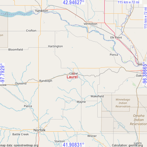
Laurel GPS coordinates[2]
42° 25' 45.984" North, 97° 5' 23.172" West
| Map corner | latitude | longitude |
|---|---|---|
| Upper-left | 42.94627°, | -97.7929° |
| Center: | 42.42944°, | -97.08977° |
| Lower-right: | 41.90831°, | -96.38665° |
| Map W x H: | 115.4×115.4 km | = 71.7×71.7mi |
| max Lat: | 71.29058° ⇑20.9% North |
| Laurel: | 42.42944° |
| min Lat: | ⇓79.1% South 19.06759° |
| min Long | Laurel | max Long |
| -171.73463° | -97.08977° | -66.98998° |
| W 24.1%⇐ | ⇒75.9% E |
Elevation
Elevation of Laurel is 450 m = 1476 ft, and this is 155.2 m = 509 ft above average elevation for this country.
| Max E: |
3189 m = 10463 ft | 13.7% |
| Laurel | 450 m 1476 ft | |
| Avg. | 294.8 m = 967 ft | |
Min E: |
-60 m = -197 ft | 86.3% |
See also: United States elevation on elevation.city.
Geographical zone
Laurel is located in North temperate zone (between Tropic of Cancer and the Arctic Circle). Distance of this Northern Tropic circle is 2111.8 km =1312.2 mi to South.| Distance of | km | miles | from Laurel |
|---|---|---|---|
| North Pole | 5289.4 | 3286.7 | to North |
| Arctic Circle | 2683.5 | 1667.4 | to North |
| Tropic Cancer | 2111.8 | 1312.2 | to South |
| Equator | 4717.7 | 2931.4 | to South |


Nearby cities:
15 places around Laurel: (largest is in red/bold)
• Bloomfield
49.3 km =30.6 mi,  292°
292°
• Crofton
47 km =29.2 mi,  315°
315°
• Elk Point
43.6 km =27.1 mi,  49°
49°
• Emerson
34.2 km =21.3 mi,  119°
119°
• Hartington
25.8 km =16 mi,  326°
326°
• Jefferson
47.6 km =29.6 mi,  66°
66°
• Osmond
42.3 km =26.3 mi,  259°
259°
• Pender
47.1 km =29.3 mi,  138°
138°
• Pierce
44.1 km =27.4 mi,  234°
234°
• Ponca
34.8 km =21.6 mi,  64°
64°
• Randolph
22.7 km =14.1 mi, 255°
• Vermillion
41.1 km =25.5 mi,  18°
18°
• Wakefield
25.7 km =16 mi,  133°
133°
• Wausa
37.9 km =23.5 mi,  281°
281°
• Wayne
22.9 km =14.2 mi,  165°
165°
Sources, notices
• [Note1] Compared only with cities in United States existing in our database
• [Src1] Map data: © OpenStreetMap contributors (CC-BY-SA)
• [Src2] Other city data from geonames.org with taken over terms of usage.
• [Src3] Geographical zone / Annual Mean Temperature by Robert A. Rohde @ Wikipedia
