Randolph geodata
Randolph (Nebraska) is a populated place; located in United States in America/Chicago (GMT-5) time zone. With population of 920 people, there are 16868 cities with bigger population in this country. Compared to other cities in United States, 78.8% of cities are located further ↓South; 76.7% of cities are located further →East and 88% of cities have lower elevation than Randolph. Note1


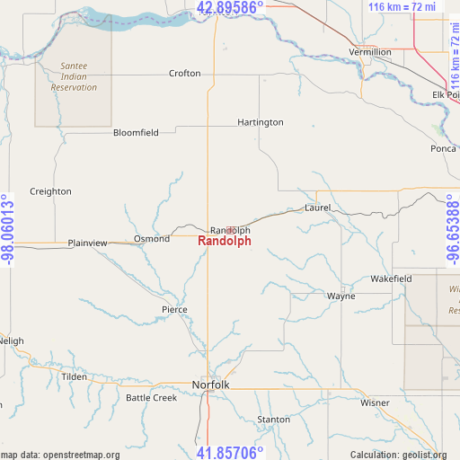
Randolph GPS coordinates[2]
42° 22' 42.996" North, 97° 21' 25.2" West
| Map corner | latitude | longitude |
|---|---|---|
| Upper-left | 42.89586°, | -98.06013° |
| Center: | 42.37861°, | -97.357° |
| Lower-right: | 41.85706°, | -96.65388° |
| Map W x H: | 115.5×115.5 km | = 71.8×71.8mi |
| max Lat: | 71.29058° ⇑21.2% North |
| Randolph: | 42.37861° |
| min Lat: | ⇓78.8% South 19.06759° |
| min Long | Randolph | max Long |
| -171.73463° | -97.357° | -66.98998° |
| W 23.3%⇐ | ⇒76.7% E |
Elevation
Elevation of Randolph is 505 m = 1657 ft, and this is 210.2 m = 690 ft above average elevation for this country.
| Max E: |
3189 m = 10463 ft | 12% |
| Randolph | 505 m 1657 ft | |
| Avg. | 294.8 m = 967 ft | |
Min E: |
-60 m = -197 ft | 88% |
See also: United States elevation on elevation.city.
Geographical zone
Randolph is located in North temperate zone (between Tropic of Cancer and the Arctic Circle). Distance of this Northern Tropic circle is 2106.1 km =1308.7 mi to South.| Distance of | km | miles | from Randolph |
|---|---|---|---|
| North Pole | 5295 | 3290.2 | to North |
| Arctic Circle | 2689.1 | 1670.9 | to North |
| Tropic Cancer | 2106.1 | 1308.7 | to South |
| Equator | 4712.1 | 2928 | to South |


Nearby cities:
15 places around Randolph: (largest is in red/bold)
• Battle Creek
46.6 km =29 mi,  205°
205°
• Bloomfield
34.1 km =21.2 mi,  315°
315°
• Center
49.7 km =30.9 mi,  301°
301°
• Creighton
46.1 km =28.6 mi,  282°
282°
• Crofton
40.6 km =25.2 mi,  343°
343°
• Hartington
28.2 km =17.5 mi,  15°
15°
• Laurel
22.7 km =14.1 mi,  75°
75°
• Norfolk
39.3 km =24.4 mi,  187°
187°
• Osmond
19.8 km =12.3 mi,  264°
264°
• Pierce
24.4 km =15.2 mi, 214°
• Plainview
35.9 km =22.3 mi, 264°
• Stanton
48.9 km =30.4 mi,  167°
167°
• Wakefield
42.2 km =26.2 mi,  106°
106°
• Wausa
20.3 km =12.6 mi,  311°
311°
• Wayne
32.4 km =20.1 mi,  120°
120°
Sources, notices
• [Note1] Compared only with cities in United States existing in our database
• [Src1] Map data: © OpenStreetMap contributors (CC-BY-SA)
• [Src2] Other city data from geonames.org with taken over terms of usage.
• [Src3] Geographical zone / Annual Mean Temperature by Robert A. Rohde @ Wikipedia
