Pierce geodata
Pierce (Nebraska) is a seat of a second-order administrative division; located in United States in America/Chicago (GMT-5) time zone. With population of 1,748 people, there are 12746 cities with bigger population in this country. Compared to other cities in United States, 77.3% of cities are located further ↓South; 77.2% of cities are located further →East and 87.4% of cities have lower elevation than Pierce. Note1


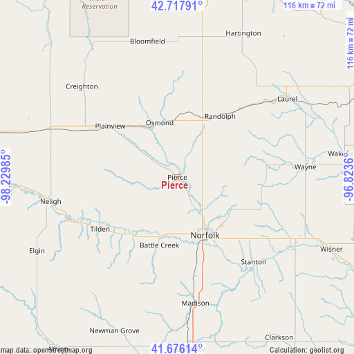
Pierce GPS coordinates[2]
42° 11' 57.012" North, 97° 31' 36.192" West
| Map corner | latitude | longitude |
|---|---|---|
| Upper-left | 42.71791°, | -98.22985° |
| Center: | 42.19917°, | -97.52672° |
| Lower-right: | 41.67614°, | -96.8236° |
| Map W x H: | 115.8×115.8 km | = 72×72mi |
| max Lat: | 71.29058° ⇑22.7% North |
| Pierce: | 42.19917° |
| min Lat: | ⇓77.3% South 19.06759° |
| min Long | Pierce | max Long |
| -171.73463° | -97.52672° | -66.98998° |
| W 22.8%⇐ | ⇒77.2% E |
Elevation
Elevation of Pierce is 484 m = 1588 ft, and this is 189.2 m = 621 ft above average elevation for this country.
| Max E: |
3189 m = 10463 ft | 12.6% |
| Pierce | 484 m 1588 ft | |
| Avg. | 294.8 m = 967 ft | |
Min E: |
-60 m = -197 ft | 87.4% |
See also: United States elevation on elevation.city.
Geographical zone
Pierce is located in North temperate zone (between Tropic of Cancer and the Arctic Circle). Distance of this Northern Tropic circle is 2086.2 km =1296.3 mi to South.| Distance of | km | miles | from Pierce |
|---|---|---|---|
| North Pole | 5315 | 3302.6 | to North |
| Arctic Circle | 2709.1 | 1683.4 | to North |
| Tropic Cancer | 2086.2 | 1296.3 | to South |
| Equator | 4692.1 | 2915.5 | to South |


Nearby cities:
15 places around Pierce: (largest is in red/bold)
• Battle Creek
23 km =14.3 mi,  194°
194°
• Bloomfield
45.5 km =28.3 mi,  347°
347°
• Creighton
43.1 km =26.8 mi,  313°
313°
• Hartington
51.8 km =32.2 mi,  24°
24°
• Laurel
44.1 km =27.4 mi,  54°
54°
• Madison
41.7 km =25.9 mi,  171°
171°
• Neligh
42.2 km =26.2 mi,  259°
259°
• Norfolk
21 km =13 mi,  154°
154°
• Osmond
18.8 km =11.7 mi,  342°
342°
• Plainview
27.5 km =17.1 mi, 307°
• Randolph
24.4 km =15.2 mi,  34°
34°
• Stanton
37.3 km =23.2 mi,  137°
137°
• Tilden
30.5 km =19 mi,  236°
236°
• Wausa
33.4 km =20.8 mi,  357°
357°
• Wayne
42.1 km =26.2 mi,  85°
85°
Sources, notices
• [Note1] Compared only with cities in United States existing in our database
• [Src1] Map data: © OpenStreetMap contributors (CC-BY-SA)
• [Src2] Other city data from geonames.org with taken over terms of usage.
• [Src3] Geographical zone / Annual Mean Temperature by Robert A. Rohde @ Wikipedia
