Wayne geodata
Wayne (Nebraska) is a seat of a second-order administrative division; located in United States in America/Chicago (GMT-5) time zone. With population of 5,569 people, there are 6705 cities with bigger population in this country. Compared to other cities in United States, 77.6% of cities are located further ↓South; 75.8% of cities are located further →East and 85.9% of cities have lower elevation than Wayne. Note1


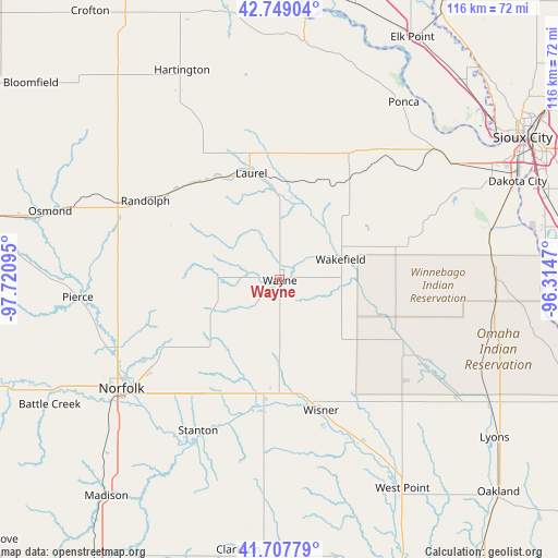
Wayne GPS coordinates[2]
42° 13' 50.016" North, 97° 1' 4.152" West
| Map corner | latitude | longitude |
|---|---|---|
| Upper-left | 42.74904°, | -97.72095° |
| Center: | 42.23056°, | -97.01782° |
| Lower-right: | 41.70779°, | -96.3147° |
| Map W x H: | 115.8×115.8 km | = 72×72mi |
| max Lat: | 71.29058° ⇑22.4% North |
| Wayne: | 42.23056° |
| min Lat: | ⇓77.6% South 19.06759° |
| min Long | Wayne | max Long |
| -171.73463° | -97.01782° | -66.98998° |
| W 24.2%⇐ | ⇒75.8% E |
Elevation
Elevation of Wayne is 441 m = 1447 ft, and this is 146.2 m = 480 ft above average elevation for this country.
| Max E: |
3189 m = 10463 ft | 14.1% |
| Wayne | 441 m 1447 ft | |
| Avg. | 294.8 m = 967 ft | |
Min E: |
-60 m = -197 ft | 85.9% |
See also: United States elevation on elevation.city.
Geographical zone
Wayne is located in North temperate zone (between Tropic of Cancer and the Arctic Circle). Distance of this Northern Tropic circle is 2089.7 km =1298.5 mi to South.| Distance of | km | miles | from Wayne |
|---|---|---|---|
| North Pole | 5311.5 | 3300.4 | to North |
| Arctic Circle | 2705.6 | 1681.2 | to North |
| Tropic Cancer | 2089.7 | 1298.5 | to South |
| Equator | 4695.6 | 2917.7 | to South |


Nearby cities:
15 places around Wayne: (largest is in red/bold)
• Beemer
37.5 km =23.3 mi,  153°
153°
• Emerson
24.5 km =15.2 mi,  77°
77°
• Hartington
48.1 km =29.9 mi,  335°
335°
• Homer
44.6 km =27.7 mi, 76°
• Laurel
22.9 km =14.2 mi,  345°
345°
• Norfolk
39.9 km =24.8 mi,  235°
235°
• Pender
28.7 km =17.8 mi,  116°
116°
• Pierce
42.1 km =26.2 mi,  265°
265°
• Ponca
44.9 km =27.9 mi,  34°
34°
• Randolph
32.4 km =20.1 mi,  300°
300°
• Stanton
35.5 km =22.1 mi,  208°
208°
• Wakefield
13.3 km =8.3 mi,  71°
71°
• Walthill
44.6 km =27.7 mi,  101°
101°
• Winnebago
44.9 km =27.9 mi,  89°
89°
• Wisner
28.4 km =17.6 mi,  162°
162°
Sources, notices
• [Note1] Compared only with cities in United States existing in our database
• [Src1] Map data: © OpenStreetMap contributors (CC-BY-SA)
• [Src2] Other city data from geonames.org with taken over terms of usage.
• [Src3] Geographical zone / Annual Mean Temperature by Robert A. Rohde @ Wikipedia
