Osceola geodata
Osceola (Nebraska) is a seat of a second-order administrative division; located in United States in America/Chicago (GMT-5) time zone. With population of 850 people, there are 17359 cities with bigger population in this country. Compared to other cities in United States, 67.7% of cities are located further ↓South; 77.3% of cities are located further →East and 88.1% of cities have lower elevation than Osceola. Note1


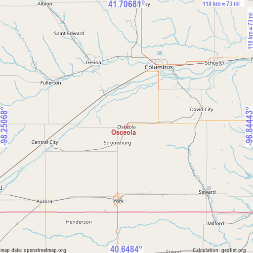
Osceola GPS coordinates[2]
41° 10' 47.064" North, 97° 32' 51.18" West
| Map corner | latitude | longitude |
|---|---|---|
| Upper-left | 41.70681°, | -98.25068° |
| Center: | 41.17974°, | -97.54755° |
| Lower-right: | 40.6484°, | -96.84443° |
| Map W x H: | 117.7×117.7 km | = 73.1×73.1mi |
| max Lat: | 71.29058° ⇑32.3% North |
| Osceola: | 41.17974° |
| min Lat: | ⇓67.7% South 19.06759° |
| min Long | Osceola | max Long |
| -171.73463° | -97.54755° | -66.98998° |
| W 22.7%⇐ | ⇒77.3% E |
Elevation
Elevation of Osceola is 510 m = 1673 ft, and this is 215.2 m = 706 ft above average elevation for this country.
| Max E: |
3189 m = 10463 ft | 11.9% |
| Osceola | 510 m 1673 ft | |
| Avg. | 294.8 m = 967 ft | |
Min E: |
-60 m = -197 ft | 88.1% |
See also: United States elevation on elevation.city.
Geographical zone
Osceola is located in North temperate zone (between Tropic of Cancer and the Arctic Circle). Distance of this Northern Tropic circle is 1972.8 km =1225.8 mi to South.| Distance of | km | miles | from Osceola |
|---|---|---|---|
| North Pole | 5428.3 | 3373 | to North |
| Arctic Circle | 2822.4 | 1753.8 | to North |
| Tropic Cancer | 1972.8 | 1225.8 | to South |
| Equator | 4578.8 | 2845.1 | to South |


Nearby cities:
15 places around Osceola: (largest is in red/bold)
• Aurora
51.7 km =32.1 mi,  227°
227°
• Central City
38.7 km =24 mi,  259°
259°
• Columbus
31.6 km =19.6 mi,  28°
28°
• David City
35.9 km =22.3 mi,  76°
76°
• Fullerton
40.7 km =25.3 mi,  300°
300°
• Genoa
33.6 km =20.9 mi,  332°
332°
• Henderson
49.7 km =30.9 mi,  206°
206°
• Humphrey
57.2 km =35.5 mi,  5°
5°
• Saint Edward
50.9 km =31.6 mi, 328°
• Schuyler
50.5 km =31.4 mi,  53°
53°
• Seward
48.3 km =30 mi,  128°
128°
• Shelby
10.3 km =6.4 mi, 82°
• Stromsburg
8.5 km =5.3 mi, 210°
• Utica
35.8 km =22.2 mi,  151°
151°
• York
34.9 km =21.7 mi,  186°
186°
Sources, notices
• [Note1] Compared only with cities in United States existing in our database
• [Src1] Map data: © OpenStreetMap contributors (CC-BY-SA)
• [Src2] Other city data from geonames.org with taken over terms of usage.
• [Src3] Geographical zone / Annual Mean Temperature by Robert A. Rohde @ Wikipedia
