Stromsburg geodata
Stromsburg (Nebraska) is a populated place; located in United States in America/Chicago (GMT-5) time zone. With population of 1,132 people, there are 15492 cities with bigger population in this country. Compared to other cities in United States, 67% of cities are located further ↓South; 77.4% of cities are located further →East and 88.2% of cities have lower elevation than Stromsburg. Note1


Stromsburg GPS coordinates[2]
41° 6' 51.048" North, 97° 35' 56.184" West
| Map corner | latitude | longitude |
|---|---|---|
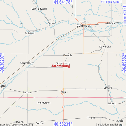
| Upper-left | 41.64178°, | -98.30207° |
| Center: | 41.11418°, | -97.59894° |
| Lower-right: | 40.58231°, | -96.89582° |
| Map W x H: | 117.8×117.8 km | = 73.2×73.2mi |
| max Lat: | 71.29058° ⇑33% North |
| Stromsburg: | 41.11418° |
| min Lat: | ⇓67% South 19.06759° |
| min Long | Stromsburg | max Long |
| -171.73463° | -97.59894° | -66.98998° |
| W 22.6%⇐ | ⇒77.4% E |
Elevation
Elevation of Stromsburg is 513 m = 1683 ft, and this is 218.2 m = 716 ft above average elevation for this country.
| Max E: |
3189 m = 10463 ft | 11.8% |
| Stromsburg | 513 m 1683 ft | |
| Avg. | 294.8 m = 967 ft | |
Min E: |
-60 m = -197 ft | 88.2% |
See also: United States elevation on elevation.city.
Geographical zone
Stromsburg is located in North temperate zone (between Tropic of Cancer and the Arctic Circle). Distance of this Northern Tropic circle is 1965.5 km =1221.3 mi to South.| Distance of | km | miles | from Stromsburg |
|---|---|---|---|
| North Pole | 5435.6 | 3377.5 | to North |
| Arctic Circle | 2829.7 | 1758.3 | to North |
| Tropic Cancer | 1965.5 | 1221.3 | to South |
| Equator | 4571.5 | 2840.6 | to South |


Nearby cities:
15 places around Stromsburg: (largest is in red/bold)
• Aurora
43.7 km =27.2 mi,  231°
231°
• Central City
33.7 km =20.9 mi,  270°
270°
• Columbus
40 km =24.9 mi,  28°
28°
• David City
42.2 km =26.2 mi,  68°
68°
• Exeter
53.7 km =33.4 mi,  166°
166°
• Fairmont
53.1 km =33 mi,  178°
178°
• Fullerton
41.5 km =25.8 mi,  311°
311°
• Genoa
38.8 km =24.1 mi,  343°
343°
• Henderson
41.3 km =25.7 mi,  205°
205°
• Osceola
8.5 km =5.3 mi, 30°
• Saint Edward
55.4 km =34.4 mi, 336°
• Seward
47.9 km =29.8 mi,  118°
118°
• Shelby
16.9 km =10.5 mi,  59°
59°
• Utica
32.3 km =20.1 mi,  138°
138°
• York
27.4 km =17 mi, 178°
Sources, notices
• [Note1] Compared only with cities in United States existing in our database
• [Src1] Map data: © OpenStreetMap contributors (CC-BY-SA)
• [Src2] Other city data from geonames.org with taken over terms of usage.
• [Src3] Geographical zone / Annual Mean Temperature by Robert A. Rohde @ Wikipedia
