Humphrey geodata
Humphrey (Nebraska) is a populated place; located in United States in America/Chicago (GMT-5) time zone. With population of 792 people, there are 17886 cities with bigger population in this country. Compared to other cities in United States, 72.8% of cities are located further ↓South; 77.1% of cities are located further →East and 88% of cities have lower elevation than Humphrey. Note1


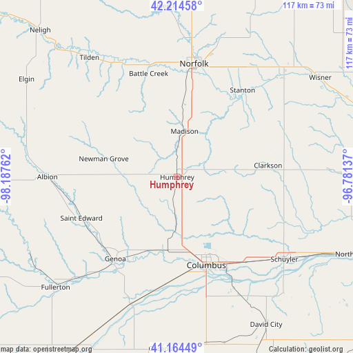
Humphrey GPS coordinates[2]
41° 41' 30.048" North, 97° 29' 4.164" West
| Map corner | latitude | longitude |
|---|---|---|
| Upper-left | 42.21458°, | -98.18762° |
| Center: | 41.69168°, | -97.48449° |
| Lower-right: | 41.16449°, | -96.78137° |
| Map W x H: | 116.8×116.8 km | = 72.6×72.6mi |
| max Lat: | 71.29058° ⇑27.2% North |
| Humphrey: | 41.69168° |
| min Lat: | ⇓72.8% South 19.06759° |
| min Long | Humphrey | max Long |
| -171.73463° | -97.48449° | -66.98998° |
| W 22.9%⇐ | ⇒77.1% E |
Elevation
Elevation of Humphrey is 507 m = 1663 ft, and this is 212.2 m = 696 ft above average elevation for this country.
| Max E: |
3189 m = 10463 ft | 12% |
| Humphrey | 507 m 1663 ft | |
| Avg. | 294.8 m = 967 ft | |
Min E: |
-60 m = -197 ft | 88% |
See also: United States elevation on elevation.city.
Geographical zone
Humphrey is located in North temperate zone (between Tropic of Cancer and the Arctic Circle). Distance of this Northern Tropic circle is 2029.8 km =1261.3 mi to South.| Distance of | km | miles | from Humphrey |
|---|---|---|---|
| North Pole | 5371.4 | 3337.6 | to North |
| Arctic Circle | 2765.5 | 1718.4 | to North |
| Tropic Cancer | 2029.8 | 1261.3 | to South |
| Equator | 4635.7 | 2880.5 | to South |


Nearby cities:
15 places around Humphrey: (largest is in red/bold)
• Albion
43.1 km =26.8 mi,  269°
269°
• Battle Creek
35.5 km =22.1 mi,  344°
344°
• Clarkson
30.3 km =18.8 mi,  82°
82°
• Columbus
30.7 km =19.1 mi,  161°
161°
• Dodge
50.1 km =31.1 mi,  86°
86°
• Fullerton
54.4 km =33.8 mi,  227°
227°
• Genoa
33.9 km =21.1 mi,  217°
217°
• Howells
40.2 km =25 mi, 84°
• Madison
15.4 km =9.6 mi,  9°
9°
• Newman Grove
25 km =15.5 mi,  285°
285°
• Norfolk
37.8 km =23.5 mi, 8°
• Saint Edward
34.5 km =21.4 mi,  246°
246°
• Schuyler
44.6 km =27.7 mi,  127°
127°
• Stanton
36 km =22.4 mi,  36°
36°
• Tilden
49 km =30.4 mi,  323°
323°
Sources, notices
• [Note1] Compared only with cities in United States existing in our database
• [Src1] Map data: © OpenStreetMap contributors (CC-BY-SA)
• [Src2] Other city data from geonames.org with taken over terms of usage.
• [Src3] Geographical zone / Annual Mean Temperature by Robert A. Rohde @ Wikipedia
