Pawnee City geodata
Pawnee City (Nebraska) is a seat of a second-order administrative division; located in United States in America/Chicago (GMT-5) time zone. With population of 827 people, there are 17545 cities with bigger population in this country. Compared to other cities in United States, 54.6% of cities are located further ↓South; 73.8% of cities are located further →East and 81.3% of cities have lower elevation than Pawnee City. Note1


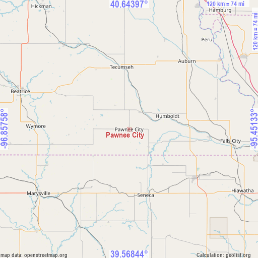
Pawnee City GPS coordinates[2]
40° 6' 29.988" North, 96° 9' 16.02" West
| Map corner | latitude | longitude |
|---|---|---|
| Upper-left | 40.64397°, | -96.85758° |
| Center: | 40.10833°, | -96.15445° |
| Lower-right: | 39.56844°, | -95.45133° |
| Map W x H: | 119.6×119.6 km | = 74.3×74.3mi |
| max Lat: | 71.29058° ⇑45.4% North |
| Pawnee City: | 40.10833° |
| min Lat: | ⇓54.6% South 19.06759° |
| min Long | Pawnee City | max Long |
| -171.73463° | -96.15445° | -66.98998° |
| W 26.2%⇐ | ⇒73.8% E |
Elevation
Elevation of Pawnee City is 368 m = 1207 ft, and this is 73.2 m = 240 ft above average elevation for this country.
| Max E: |
3189 m = 10463 ft | 18.7% |
| Pawnee City | 368 m 1207 ft | |
| Avg. | 294.8 m = 967 ft | |
Min E: |
-60 m = -197 ft | 81.3% |
See also: United States elevation on elevation.city.
Geographical zone
Pawnee City is located in North temperate zone (between Tropic of Cancer and the Arctic Circle). Distance of this Northern Tropic circle is 1853.7 km =1151.8 mi to South.| Distance of | km | miles | from Pawnee City |
|---|---|---|---|
| North Pole | 5547.4 | 3447 | to North |
| Arctic Circle | 2941.5 | 1827.8 | to North |
| Tropic Cancer | 1853.7 | 1151.8 | to South |
| Equator | 4459.6 | 2771.1 | to South |


Nearby cities:
15 places around Pawnee City: (largest is in red/bold)
• Adams
49.3 km =30.6 mi,  322°
322°
• Auburn
41.4 km =25.7 mi,  40°
40°
• Beatrice
53.4 km =33.2 mi,  289°
289°
• Centralia
42.6 km =26.5 mi,  176°
176°
• Falls City
47.3 km =29.4 mi,  96°
96°
• Firth
60.8 km =37.8 mi, 320°
• Frankfort
50.1 km =31.1 mi,  206°
206°
• Hiawatha
59.9 km =37.2 mi,  118°
118°
• Humboldt
18.8 km =11.7 mi,  70°
70°
• Marysville
51.4 km =31.9 mi,  234°
234°
• Peru
54.1 km =33.6 mi, 41°
• Sabetha
37.8 km =23.5 mi,  127°
127°
• Seneca
31.4 km =19.5 mi,  165°
165°
• Tecumseh
28.9 km =18 mi,  352°
352°
• Wymore
43.2 km =26.8 mi,  272°
272°
Sources, notices
• [Note1] Compared only with cities in United States existing in our database
• [Src1] Map data: © OpenStreetMap contributors (CC-BY-SA)
• [Src2] Other city data from geonames.org with taken over terms of usage.
• [Src3] Geographical zone / Annual Mean Temperature by Robert A. Rohde @ Wikipedia
