Wymore geodata
Wymore (Nebraska) is a populated place; located in United States in America/Chicago (GMT-5) time zone. With population of 1,414 people, there are 14047 cities with bigger population in this country. Compared to other cities in United States, 54.8% of cities are located further ↓South; 74.8% of cities are located further →East and 82.1% of cities have lower elevation than Wymore. Note1
Administrative division(s):
- Level 1: Nebraska
- Level 2: Gage County
- Level 3: Township of Blue Springs-Wymore


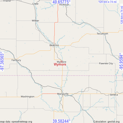
Wymore GPS coordinates[2]
40° 7' 19.992" North, 96° 39' 45.072" West
| Map corner | latitude | longitude |
|---|---|---|
| Upper-left | 40.65775°, | -97.36565° |
| Center: | 40.12222°, | -96.66252° |
| Lower-right: | 39.58244°, | -95.9594° |
| Map W x H: | 119.6×119.6 km | = 74.3×74.3mi |
| max Lat: | 71.29058° ⇑45.2% North |
| Wymore: | 40.12222° |
| min Lat: | ⇓54.8% South 19.06759° |
| min Long | Wymore | max Long |
| -171.73463° | -96.66252° | -66.98998° |
| W 25.2%⇐ | ⇒74.8% E |
Elevation
Elevation of Wymore is 377 m = 1237 ft, and this is 82.2 m = 270 ft above average elevation for this country.
| Max E: |
3189 m = 10463 ft | 17.9% |
| Wymore | 377 m 1237 ft | |
| Avg. | 294.8 m = 967 ft | |
Min E: |
-60 m = -197 ft | 82.1% |
See also: United States elevation on elevation.city.
Geographical zone
Wymore is located in North temperate zone (between Tropic of Cancer and the Arctic Circle). Distance of this Northern Tropic circle is 1855.3 km =1152.8 mi to South.| Distance of | km | miles | from Wymore |
|---|---|---|---|
| North Pole | 5545.9 | 3446.1 | to North |
| Arctic Circle | 2940 | 1826.8 | to North |
| Tropic Cancer | 1855.3 | 1152.8 | to South |
| Equator | 4461.2 | 2772.1 | to South |


Nearby cities:
15 places around Wymore: (largest is in red/bold)
• Adams
39.7 km =24.7 mi,  19°
19°
• Beatrice
17.7 km =11 mi,  336°
336°
• Blue Rapids
49 km =30.4 mi,  179°
179°
• De Witt
37.4 km =23.2 mi,  323°
323°
• Fairbury
44.1 km =27.4 mi,  272°
272°
• Firth
45.9 km =28.5 mi,  5°
5°
• Frankfort
50.8 km =31.6 mi,  155°
155°
• Hanover
31.4 km =19.5 mi,  216°
216°
• Hickman
55.4 km =34.4 mi,  2°
2°
• Marysville
31.3 km =19.4 mi, 177°
• Pawnee City
43.2 km =26.8 mi,  92°
92°
• Tecumseh
48 km =29.8 mi,  55°
55°
• Washington
47.3 km =29.4 mi, 224°
• Waterville
48.5 km =30.1 mi,  188°
188°
• Wilber
47.3 km =29.4 mi,  327°
327°
Sources, notices
• [Note1] Compared only with cities in United States existing in our database
• [Src1] Map data: © OpenStreetMap contributors (CC-BY-SA)
• [Src2] Other city data from geonames.org with taken over terms of usage.
• [Src3] Geographical zone / Annual Mean Temperature by Robert A. Rohde @ Wikipedia
