Beatrice geodata
Beatrice (Nebraska) is a seat of a second-order administrative division; located in United States in America/Chicago (GMT-5) time zone. With population of 12,388 people, there are 3798 cities with bigger population in this country. Compared to other cities in United States, 56.2% of cities are located further ↓South; 75% of cities are located further →East and 83.3% of cities have lower elevation than Beatrice. Note1


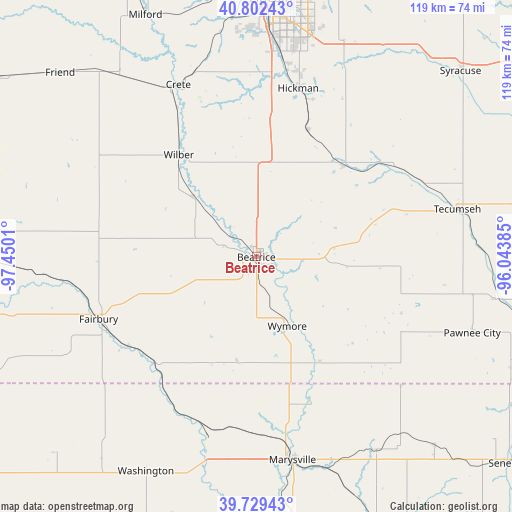
Beatrice GPS coordinates[2]
40° 16' 5.016" North, 96° 44' 49.092" West
| Map corner | latitude | longitude |
|---|---|---|
| Upper-left | 40.80243°, | -97.4501° |
| Center: | 40.26806°, | -96.74697° |
| Lower-right: | 39.72943°, | -96.04385° |
| Map W x H: | 119.3×119.3 km | = 74.1×74.1mi |
| max Lat: | 71.29058° ⇑43.8% North |
| Beatrice: | 40.26806° |
| min Lat: | ⇓56.2% South 19.06759° |
| min Long | Beatrice | max Long |
| -171.73463° | -96.74697° | -66.98998° |
| W 25%⇐ | ⇒75% E |
Elevation
Elevation of Beatrice is 395 m = 1296 ft, and this is 100.2 m = 329 ft above average elevation for this country.
| Max E: |
3189 m = 10463 ft | 16.7% |
| Beatrice | 395 m 1296 ft | |
| Avg. | 294.8 m = 967 ft | |
Min E: |
-60 m = -197 ft | 83.3% |
See also: United States elevation on elevation.city.
Geographical zone
Beatrice is located in North temperate zone (between Tropic of Cancer and the Arctic Circle). Distance of this Northern Tropic circle is 1871.5 km =1162.9 mi to South.| Distance of | km | miles | from Beatrice |
|---|---|---|---|
| North Pole | 5529.7 | 3436 | to North |
| Arctic Circle | 2923.8 | 1816.8 | to North |
| Tropic Cancer | 1871.5 | 1162.9 | to South |
| Equator | 4477.4 | 2782.1 | to South |


Nearby cities:
15 places around Beatrice: (largest is in red/bold)
• Adams
29.3 km =18.2 mi,  43°
43°
• Bennet
50.1 km =31.1 mi,  23°
23°
• Crete
43.9 km =27.3 mi,  335°
335°
• De Witt
20.4 km =12.7 mi,  313°
313°
• Dorchester
52.3 km =32.5 mi,  323°
323°
• Fairbury
39.6 km =24.6 mi,  248°
248°
• Firth
31.7 km =19.7 mi, 22°
• Hanover
43.1 km =26.8 mi,  195°
195°
• Hickman
40.4 km =25.1 mi,  14°
14°
• Marysville
48.2 km =30 mi,  169°
169°
• Pawnee City
53.4 km =33.2 mi,  109°
109°
• Tecumseh
48 km =29.8 mi,  76°
76°
• Washington
56.3 km =35 mi,  207°
207°
• Wilber
29.8 km =18.5 mi, 322°
• Wymore
17.7 km =11 mi,  156°
156°
Sources, notices
• [Note1] Compared only with cities in United States existing in our database
• [Src1] Map data: © OpenStreetMap contributors (CC-BY-SA)
• [Src2] Other city data from geonames.org with taken over terms of usage.
• [Src3] Geographical zone / Annual Mean Temperature by Robert A. Rohde @ Wikipedia
