Shelton geodata
Shelton (Nebraska) is a populated place; located in United States in America/Chicago (GMT-5) time zone. With population of 1,064 people, there are 15874 cities with bigger population in this country. Compared to other cities in United States, 62.8% of cities are located further ↓South; 79.7% of cities are located further →East and 89.9% of cities have lower elevation than Shelton. Note1


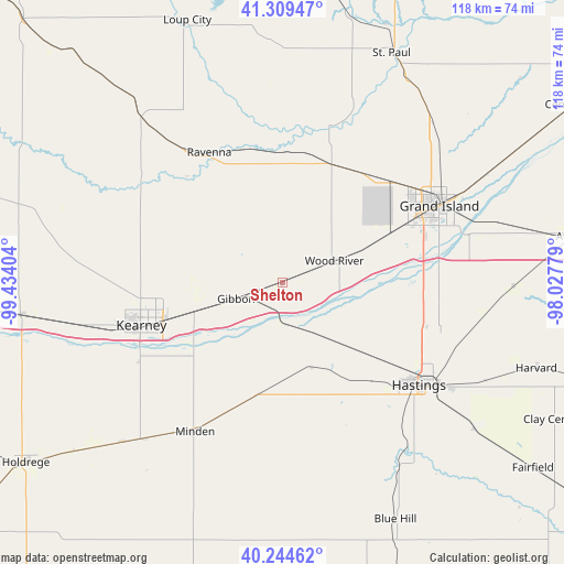
Shelton GPS coordinates[2]
40° 46' 45.048" North, 98° 43' 51.276" West
| Map corner | latitude | longitude |
|---|---|---|
| Upper-left | 41.30947°, | -99.43404° |
| Center: | 40.77918°, | -98.73091° |
| Lower-right: | 40.24462°, | -98.02779° |
| Map W x H: | 118.4×118.4 km | = 73.6×73.6mi |
| max Lat: | 71.29058° ⇑37.2% North |
| Shelton: | 40.77918° |
| min Lat: | ⇓62.8% South 19.06759° |
| min Long | Shelton | max Long |
| -171.73463° | -98.73091° | -66.98998° |
| W 20.3%⇐ | ⇒79.7% E |
Elevation
Elevation of Shelton is 619 m = 2031 ft, and this is 324.2 m = 1064 ft above average elevation for this country.
| Max E: |
3189 m = 10463 ft | 10.1% |
| Shelton | 619 m 2031 ft | |
| Avg. | 294.8 m = 967 ft | |
Min E: |
-60 m = -197 ft | 89.9% |
See also: United States elevation on elevation.city.
Geographical zone
Shelton is located in North temperate zone (between Tropic of Cancer and the Arctic Circle). Distance of this Northern Tropic circle is 1928.3 km =1198.2 mi to South.| Distance of | km | miles | from Shelton |
|---|---|---|---|
| North Pole | 5472.8 | 3400.6 | to North |
| Arctic Circle | 2867 | 1781.5 | to North |
| Tropic Cancer | 1928.3 | 1198.2 | to South |
| Equator | 4534.2 | 2817.4 | to South |


Nearby cities:
15 places around Shelton: (largest is in red/bold)
• Alda
24.4 km =15.2 mi,  65°
65°
• Axtell
47.3 km =29.4 mi,  224°
224°
• Cairo
26.8 km =16.7 mi,  22°
22°
• Doniphan
30.4 km =18.9 mi,  91°
91°
• Elm Creek
54.4 km =33.8 mi,  262°
262°
• Gibbon
10.2 km =6.3 mi,  250°
250°
• Grand Island
36.5 km =22.7 mi,  63°
63°
• Hastings
36 km =22.4 mi,  126°
126°
• Juniata
28.3 km =17.6 mi,  137°
137°
• Kearney
30.8 km =19.1 mi, 253°
• Kenesaw
18.6 km =11.6 mi,  160°
160°
• Minden
36.2 km =22.5 mi,  210°
210°
• Ravenna
31.4 km =19.5 mi,  330°
330°
• Saint Paul
53.6 km =33.3 mi,  25°
25°
• Wood River
11.9 km =7.4 mi, 67°
Sources, notices
• [Note1] Compared only with cities in United States existing in our database
• [Src1] Map data: © OpenStreetMap contributors (CC-BY-SA)
• [Src2] Other city data from geonames.org with taken over terms of usage.
• [Src3] Geographical zone / Annual Mean Temperature by Robert A. Rohde @ Wikipedia
