Wood River geodata
Wood River (Nebraska) is a populated place; located in United States in America/Chicago (GMT-5) time zone. With population of 1,367 people, there are 14276 cities with bigger population in this country. Compared to other cities in United States, 63.5% of cities are located further ↓South; 79.5% of cities are located further →East and 89.7% of cities have lower elevation than Wood River. Note1


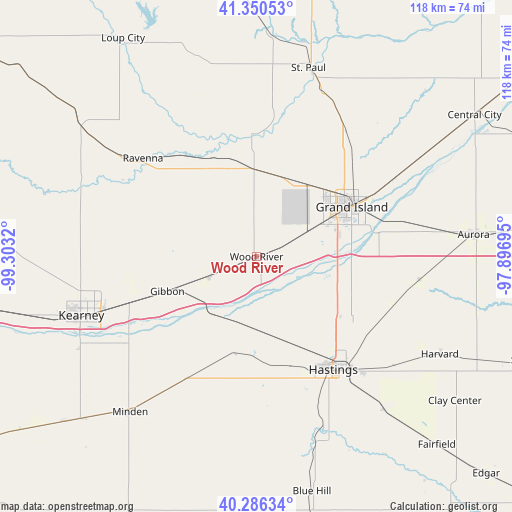
Wood River GPS coordinates[2]
40° 49' 14.052" North, 98° 36' 0.252" West
| Map corner | latitude | longitude |
|---|---|---|
| Upper-left | 41.35053°, | -99.3032° |
| Center: | 40.82057°, | -98.60007° |
| Lower-right: | 40.28634°, | -97.89695° |
| Map W x H: | 118.3×118.3 km | = 73.5×73.5mi |
| max Lat: | 71.29058° ⇑36.5% North |
| Wood River: | 40.82057° |
| min Lat: | ⇓63.5% South 19.06759° |
| min Long | Wood River | max Long |
| -171.73463° | -98.60007° | -66.98998° |
| W 20.5%⇐ | ⇒79.5% E |
Elevation
Elevation of Wood River is 601 m = 1972 ft, and this is 306.2 m = 1005 ft above average elevation for this country.
| Max E: |
3189 m = 10463 ft | 10.3% |
| Wood River | 601 m 1972 ft | |
| Avg. | 294.8 m = 967 ft | |
Min E: |
-60 m = -197 ft | 89.7% |
See also: United States elevation on elevation.city.
Geographical zone
Wood River is located in North temperate zone (between Tropic of Cancer and the Arctic Circle). Distance of this Northern Tropic circle is 1932.9 km =1201 mi to South.| Distance of | km | miles | from Wood River |
|---|---|---|---|
| North Pole | 5468.2 | 3397.8 | to North |
| Arctic Circle | 2862.4 | 1778.6 | to North |
| Tropic Cancer | 1932.9 | 1201 | to South |
| Equator | 4538.8 | 2820.3 | to South |


Nearby cities:
15 places around Wood River: (largest is in red/bold)
• Alda
12.4 km =7.7 mi,  63°
63°
• Aurora
50.4 km =31.3 mi,  84°
84°
• Cairo
20.1 km =12.5 mi,  358°
358°
• Doniphan
20.1 km =12.5 mi,  105°
105°
• Gibbon
22.1 km =13.7 mi,  248°
248°
• Grand Island
24.6 km =15.3 mi, 61°
• Harvard
47.9 km =29.8 mi,  117°
117°
• Hastings
31.6 km =19.6 mi,  145°
145°
• Juniata
26.8 km =16.7 mi,  162°
162°
• Kearney
42.7 km =26.5 mi, 251°
• Kenesaw
22.7 km =14.1 mi,  192°
192°
• Minden
46.3 km =28.8 mi,  219°
219°
• Ravenna
34.8 km =21.6 mi,  311°
311°
• Saint Paul
45.4 km =28.2 mi,  15°
15°
• Shelton
11.9 km =7.4 mi, 247°
Sources, notices
• [Note1] Compared only with cities in United States existing in our database
• [Src1] Map data: © OpenStreetMap contributors (CC-BY-SA)
• [Src2] Other city data from geonames.org with taken over terms of usage.
• [Src3] Geographical zone / Annual Mean Temperature by Robert A. Rohde @ Wikipedia
