Wahoo geodata
Wahoo (Nebraska) is a seat of a second-order administrative division; located in United States in America/Chicago (GMT-5) time zone. With population of 4,511 people, there are 7635 cities with bigger population in this country. Compared to other cities in United States, 67.9% of cities are located further ↓South; 74.7% of cities are located further →East and 81.6% of cities have lower elevation than Wahoo. Note1


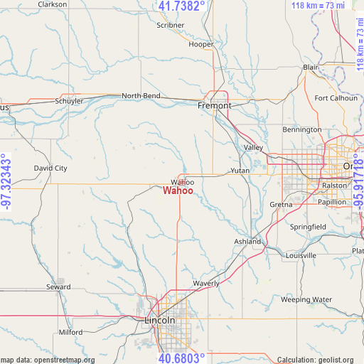
Wahoo GPS coordinates[2]
41° 12' 41.004" North, 96° 37' 13.08" West
| Map corner | latitude | longitude |
|---|---|---|
| Upper-left | 41.7382°, | -97.32343° |
| Center: | 41.21139°, | -96.6203° |
| Lower-right: | 40.6803°, | -95.91718° |
| Map W x H: | 117.6×117.6 km | = 73.1×73.1mi |
| max Lat: | 71.29058° ⇑32.1% North |
| Wahoo: | 41.21139° |
| min Lat: | ⇓67.9% South 19.06759° |
| min Long | Wahoo | max Long |
| -171.73463° | -96.6203° | -66.98998° |
| W 25.3%⇐ | ⇒74.7% E |
Elevation
Elevation of Wahoo is 371 m = 1217 ft, and this is 76.2 m = 250 ft above average elevation for this country.
| Max E: |
3189 m = 10463 ft | 18.4% |
| Wahoo | 371 m 1217 ft | |
| Avg. | 294.8 m = 967 ft | |
Min E: |
-60 m = -197 ft | 81.6% |
See also: United States elevation on elevation.city.
Geographical zone
Wahoo is located in North temperate zone (between Tropic of Cancer and the Arctic Circle). Distance of this Northern Tropic circle is 1976.4 km =1228.1 mi to South.| Distance of | km | miles | from Wahoo |
|---|---|---|---|
| North Pole | 5424.8 | 3370.8 | to North |
| Arctic Circle | 2818.9 | 1751.6 | to North |
| Tropic Cancer | 1976.4 | 1228.1 | to South |
| Equator | 4582.3 | 2847.3 | to South |


Nearby cities:
15 places around Wahoo: (largest is in red/bold)
• Arlington
35 km =21.7 mi,  39°
39°
• Ashland
28.5 km =17.7 mi,  132°
132°
• Cedar Bluffs
20.6 km =12.8 mi,  2°
2°
• Ceresco
17.3 km =10.7 mi,  186°
186°
• Elkhorn
33.3 km =20.7 mi,  75°
75°
• Fremont
26.7 km =16.6 mi,  22°
22°
• Greenwood
31.5 km =19.6 mi,  151°
151°
• Gretna
32.8 km =20.4 mi,  103°
103°
• Mead
11.2 km =7 mi, 80°
• North Bend
30.9 km =19.2 mi,  334°
334°
• Valley
25.5 km =15.8 mi,  63°
63°
• Valparaiso
22.9 km =14.2 mi,  230°
230°
• Waterloo
29.2 km =18.1 mi,  73°
73°
• Waverly
33.6 km =20.9 mi,  166°
166°
• Yutan
19 km =11.8 mi, 78°
Sources, notices
• [Note1] Compared only with cities in United States existing in our database
• [Src1] Map data: © OpenStreetMap contributors (CC-BY-SA)
• [Src2] Other city data from geonames.org with taken over terms of usage.
• [Src3] Geographical zone / Annual Mean Temperature by Robert A. Rohde @ Wikipedia
